Like Urban Research on Facebook

Monday, March 26, 2012

Seven Rules for Sustainable Communities: Design Strategies for the Post-Carbon World


Patrick M. Condon, the James Taylor Chair in Landscape and Liveable Environments at the University of British Columbia, has just written a new book Seven Rules for Sustainable Communities: Design Strategies for the Post-Carbon World. The book aims to be an easy-to-use guide to basic urban design rules that, if followed, can help begin to halt the buildup of greenhouse gasses and create a more livable world for future generations.
It starts from a premise that Worldchanging covers regularly: the transformation of cities and metropolitan regions "into places that strike a balance between their human inhabitants and the planet's air and water systems" with compact, energy-efficient, and pedestrian- and transit-friendly design is the key to a bright green future. 


more book reviews:

Ecologist Stuart Cowan reviews The Nature of Order: Unfolding a Sustainable World.

Leon Krier's lesson in architecture

Urbanism in the Age of Climate Change

Book Review: Waiting on a Train

Book Review: Instant City

The City Beautiful Movement by William H. Wilson

Biophilic Cities: Integrating Nature into Urban Design and Planning

The Unsquared Circle of Old Shanghai

by Christopher Szabla 

Take a look at a map of Shanghai and it still jumps out at you — a tightly-wound ball of narrow streets threading through warrens of centuries-old houses. Call it what you will — the neighborhood seems to have no standard English name, and “Old City,” “Round City,” or simply “Old Shanghai” have been used before — but it’s impossible to deny this slice of China’s largest city stands a bit aloof; what’s left of it appears to exist in total defiance of a metropolis that appears ceaselessly hungry for towers that soar high enough to match the gaping width of its newly-broadened boulevards.
Old Shanghai’s uniqueness is a longstanding trend; the last time the neighborhood didn’t buck the rest of the city’s form was during the Middle Ages, when the Round City was Shanghai — a fledgling Ming Dynasty port. But skip forward to the 19th century and Shanghai has grown to become the hub of foreign commerce in China, its cityscape defined by the architecture the colonial powers have brought to their respective concessions — tiny fiefdoms run by local Westerners nominally reporting to overseas capitals.
Somewhat like Hong Hong’s Kowloon Walled City nearly a century later, the Old City, or “Chinese City,” as it began, then, to be called, remained an enclave within these enclaves, a densely-packed and ghettoized dormitory for much of the city’s local workforce. It even remained behind literal, medieval walls — until, during China’s 1911 revolution, they finally came crashing down.


Birdsview of old Shanghai
more about urban China:

Reliable and valid NEWS for Chinese seniors: measuring perceived neighborhood attributes related to walking

SOM wins Beijing Bohai Innovation City Master Plan Competition

THE ROLE OF SPACE SYNTAX IN SPATIAL COGNITION: evidence from urban China

REMOTE SENSING IMAGE INTERPRETATION STUDY SERVING URBAN PLANNING BASED ON GIS

China's Urban Low Carbon Future in Shanghai

Harmony at the Guangzhou Opera House by Zaha Hadid

LANDSCAPE EFFECTS OF URBAN SPRAWL: SPATIAL AND TEMPORAL ANALYSES USING REMOTE SENSING IMAGES AND LANDSCAPE METRICS

by Wei Ji,

This study intends to identify both general trends and subtle patterns of urban land changes of the past three decades in metropolitan Kansas City area. Landsat images were used to generate time series of land cover data from the early 1970s to the early 2000s. Based on remotely sensed land cover data, landscape metrics were calculated. Both the remotely sensed data and landscape metrics were used to characterize long-term trends and patterns of landscape effects of urban sprawl. Land cover change analyses at the metropolitan, county, and city levels reveal that over the past three decades the significant increase of built-up land in the study area was mainly at the expense of non-forest vegetation cover. The spatial and temporal heterogeneity of land cover changes allowed the identification of the built-up land spread patterns. The landscape metrics were analyzed to quantify the fragmentation of land covers and degrees of urban built-up activities across the study area.


more about urban sprawl:

Urban form and the ecological footprint of commuting. The case of Barcelona

Studying the effects of urban sprawl of metropolis on tourism - climate index oscillation: A case study of Tehran city

Suitability criteria for measures of urban sprawl

On defining "Sprawl"

Compact Sprawl Experiments four strategic densification scenarios for two modernist suburbs in Stockholm

Neighborhood Design and the Accessibility of the Elderly: An Empirical Analysis in Northern California

Monday, March 19, 2012

Reduction of CO2 emissions of transport by reorganisation of urban activities

by Michael Wegener

It is generally believed that the private automobile has been the primary cause of the expansion of cities over wider and wider areas. However suburbanisation was not caused by the car but has been the consequence of the same changes in the socio-economic context of urban life that were also responsible for the growth in car ownership: increase in income, more working women, smaller households, shorter work hours and a consequential change in lifestyles and housing preferences towards quality of life, leisure and recreation. Under these conditions, the car and low fuel prices brought low-density suburban living within the reach of not only the rich, with the result that for the last thirty years the growth of cities has occurred primarily in the suburbs. Offices, light industry, services and retail started to decentralise later following either their employees or their markets or both taking advantage of attractive suburban locations with good accessibility, ample parking and lower land prices.
However, while this deconcentration process clearly reflects the preferences of the majority of the population, its negative side effects are more and more becoming apparent: longer work and shopping trips, increasing rush-hour congestion and less and less acceptable levels of noise, air pollution and traffic accidents. In particular the high energy consumption of transport in lowdensity cities has become an issue of growing concern. The fear of diminishing fossil fuels and the threat of long-term climate changes due to greenhouse gases have sharpened the awareness that present energy prices do not nearly cover the environmental and social costs of energy use and that the level of energy consumption in affluent countries represents a gross unfairness against developing countries which can never be allowed to rise to the same standards. At the United Nations conference on the global environment in Rio de Janeiro in 1992 many governments pledged to substantially reduce their use of fossil energy and emissions of carbon dioxide (CO2). The German government promised to reduce CO2 emissions from all sources by 30 percent compared with 1987 by 2005. As transport represents a major share of primary energy consumption, serious attempts to lower the energy use of urban transport are necessary to achieve this goal.

Major subsystems of the Dortmund model. Taken from the above paper: Paper presented at the seminar of the Special Interest Group Transport and Spatial Development of the World Conference on Transport Research (WCTRS) in Blackheath, Australia, in December 1993. Published in: Hayashi, Y., Roy, J., eds. (1996): Transport, Land-Use and the Environment, Dordrecht: Kluwer Academic Publishers, 103-124.

similar posts:

Modeling the environmental impacts of urban land use and land cover change—a study in Merseyside, UK

Low Carbon City Development Guidance [Outline]

Healthy Urban Planning The Concept, Tools, and Application

UNDERSTANDING URBAN GROWTH PATTERNS: A LANDSCAPE ECOLOGY POINT OF VIEW

Applying principles of Landscape Ecology to Green Infrastructure planning

THE IMPACT OF URBAN DEVELOPMENT ON AIR QUALITY AND ENERGY USE

by P.C. Manins, M.E. Cope, P.J. Hurley, P.W. Newton, N.C. Smith and L.O. Marquez

Melbourne has been used as a case study to investigate the effects of six alternative urban forms on air quality. The forms are Dispersed City, Compact City, Corridor City, Multi-Nodal City, Fringe-Development City and 'Business-As-Usual' City. We took 1991 as the base year, using emissions, population and transport data supplied by EPA Victoria. We specified changes in activities for each alternative development to the year 2011. We used an integrated landuse-transport optimisation model (Topaz 2000) to predict the changed emissions for each scenario. A coupled 3-D meteorological model (LADM) and photochemical airshed model (extended CIT model) were used to predict the hour by hour air quality conditions on an adverse winter day and an adverse summer day. For the modelled cases we found: Photochemical Smog. The exposure levels show a 55% improvement from base year for the Corridor City, compared with a 71% worsening for Business as Usual. Particulate Pollution. With particulate build up, there would be an improvement of 14% for the Corridor City and a worsening by 61% for Business as Usual compared to the base case. Exposure in the Compact City is, for the given emission load, substantially worse than in any other.

Archetypal Urban Systems. Taken from the above paper: Manins PC, Cope ME, Hurley PJ, Newton PW, Smith NC, Marquez LO. 1998. The impact of urban development on air quality and energy use. In: Proceedings of the 14th International Clean Air and Environment Conference, Melbourne. Mitcham, VIC. Clean Air Society of Australia and New Zealand. Pp. 331-336.

similar posts:

Urban form and the ecological footprint of commuting. The case of Barcelona

Modeling Energy Consumption and CO2 Emissions at the Urban Scale: Methodological Challenges and Insights from the United States

California’s Policy Model to Reduce Oil Use and Vehicle Emissions

Interconnections of Urban Green Spaces and Environmental Quality of Tehran

Urban Ecological landscape of Tehran

Analyzing Land Use Change In Urban Environments

Modeling Energy Consumption and CO2 Emissions at the Urban Scale: Methodological Challenges and Insights from the United States

by Lily Parshall, Kevin Gurney, Stephen A. Hammer, Daniel Mendoza, Yuyu Zhou, and Sarath Geethakumar

Local policy makers could benefit from a national, high-resolution inventory of energy consumption and related carbon dioxide (CO2) emissions based on the Vulcan data product, which plots emissions on a 100-km2 grid. We evaluate the ability of Vulcan to measure energy consumption in urban areas, a scale of analysis required to support goals established as part of local energy, climate or sustainability initiatives. We highlight the methodological challenges of this type of analytical exercise and review alternative approaches. We find that between 37% and 86% of direct fuel consumption in buildings and industry and between 37% and 77% of on-road gasoline and diesel consumption occurs in urban areas, depending on how these areas are defined. We suggest that a county-based definition of urban is preferable to other common definitions since counties are the smallest political unit for which energy data are collected. Urban counties, as defined by Isserman (2005), account for 37% of direct energy consumption, or 50% if mixed urban counties are included. A county-based definition can also improve estimates of per-capita consumption and the carbon intensity of energy use.


more about energy consumption:

Urban form and the ecological footprint of commuting. The case of Barcelona

TRANSPORT MANAGEMENT IN IRAN: TRAFFIC SAFETY AND CLEANER CARS

Germany Sets Aside $130 Billion for Renewable Energy

Urbanization and Environmental Sustainability

THE FUTURE OF MOBILITY IN CITIES: CHALLENGES FOR URBAN MODELLING

The Human Benefits of Green Building

Integrated Systems Planning for Energy Efficiency and Conservation

Urban form and the ecological footprint of commuting. The case of Barcelona

by Ivan Mun˜iz and Anna Galindo

One of the most controversial ideas in the debate on urban sustainability is that urban sprawl causes problems of ecological stress. This widespread assumption has been tested by measuring the ecological footprint left by commuters in the 163 municipalities of the Barcelona Metropolitan Region (BMR). This paper explores the determinants of the ecological footprint of commuting municipal variability by using the following regressors: population density, accessibility, average household income, and job ratio. The results confirm that urban form appears as the main determinant of ecological footprint variation among the municipalities of BMR.


more about urban Spain:

Street Centrality and the Location of Economic Activities in Barcelona

Montjuic Communications Tower built for the 1992 Olympics in Barcelona

skyline photos of Madrid 1

Toward Low Carbon Cities: Madrid and London

Routes of Gothic

THE URBAN SPRAWL: A PLANETARY GROWTH PROCESS? AN OVERVIEW OF USA, MEXICO AND SPAIN

INTEGRATING PLACE IDENTITY, URBAN SUSTAINABILITY AND GLOBALIZATION: A GREAT CHALLENGE FOR THE CITY OF THE FUTURE

The Public transport and priority to pedestrians and bicycles as a basis for the quality of life in capital cities

Friday, March 16, 2012

Studying the effects of urban sprawl of metropolis on tourism - climate index oscillation: A case study of Tehran city

by Gholamreza Roshan, Iman Rousta and Mehdi Ramesh

The present research intends to identify the effects of urban sprawl of metropolis on tourism-climate index oscillation. To do this research, two types of data have been used. The first type includes climate data such as minimum monthly temperature average, monthly temperature average, minimum relative humidity rate and monthly relative humidity average, average of wind speed, duration of sunshine and monthly rainfall, and the second component includes parameters related to urban sprawl components of Tehran city such as number of population, density, expansion and number of automobiles per 100 persons. In this research in order to identify climate-tourism range for different months TCI coefficient has been used. Based on the results taken from the average of three 18-year periods using TCI index, it has been concluded that time oscillation is seen for the majority of months in qualitative and quantitative range of climate-tourism coefficient. In a way that these time oscillations of TCI has positive trend for some months and negative for others. In the next step after making correlation between the components of urban sprawl of Tehran city with TCI index, it has been concluded that in April, May, September and November, the results show that the components of urban sprawl of the city has direct effect on providing more suitable climate-tourism conditions, however in June, July, August and September, the components of urban sprawl of the city has had a negative effect on TCI index. But in general, considering the outcome results for annual statistics, we can conclude that urban sprawl of metropolis of Tehran has had a negative effect on TCI index and this factor can be followed by undesirable conditions for Tehran in view of climate comfort in future and it will be considered as a difficulty in view of biologic conditions for tourists.

The chronological development of Tehran between 1952 and 2006, source: Zanganeh SS (2006). The analysis of Tehran urban sprawl and its effect on agricultural lands, M A Thesis in Geography and Urban Planning, University of Tehran (In Persian)

more about the urbanism of Iran:

TRANSPORT MANAGEMENT IN IRAN: TRAFFIC SAFETY AND CLEANER CARS

An Analysis to Challenges of Urban Management in Historic Center of Cities in Iran

COMPARATIVE SUSTAINABILITY OF BAZAAR IN IRANIAN TRADITIONAL CITIES: CASE STUDIES IN ISFAHAN AND TABRIZ

AIR QUALITY MANAGEMENT IN TEHRAN

STRATEGY FOR SUSTAINABLE URBAN DEVELOPMENT GUIDELINES FOR TEHRAN

IRAN’S MASHHAD LRT OPEN

URBAN SPRAWL AND CLIMATIC CHANGES IN TEHRAN

Thursday, March 15, 2012

Skyline photos of Miami, Florida (1)

MIAMI SKYLINE Miami's MacArthur Causeway at Twilight Miami Skyline Miami Skyline Miami skyline Miami Skyline Miami and it's industry Miami Skyline Miami Skyline Miami Skyline Miami Skyline Miami Skyline


more skyline photos:

Skyline photos of Prague, Czech Republic (2)

Skyline photos of Prague, Czech Republic (1)

Skyline photos of Sydney, Australia (2)

Skyline photos of Brussels, Belgium -1

Skyline photos of Düsseldorf, Germany

Skyline photos of Manchester 1

Skyline photos of Phoenix, Arizona

Skyline of Phoenix, Arizona, by Dru Bloomfield - At Home in Scottsdale

Skyline of Phoenix, Arizona, by phxwebguy

Skyline of Phoenix, Arizona, by Kingdafy

Skyline of Phoenix, Arizona, by MPR529

Skyline of Phoenix, Arizona, by Kingdafy
more skyline photos:

Skyline photos of Portland, Oregon (2)

Skyline photos of Montreal, Canada (2)

Skyline photos of San Diego, California

Skyline photos of Portland, Oregon 1

Skyline photos of Marseille, France

Skyline photos of Hamburg, Germany 1

Skyline photos of Madrid 2

Suitability criteria for measures of urban sprawl

by Jochen A.G. Jaeger a, Rene´ Bertiller, Christian Schwick, and Felix Kienast

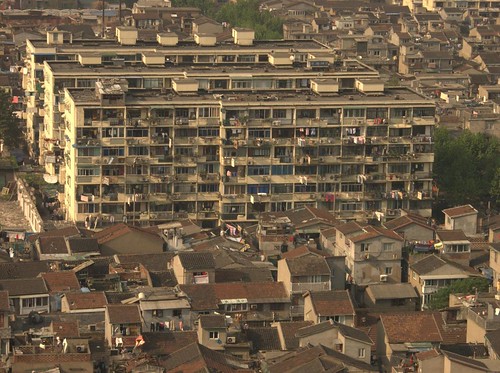
Rapid increase of urban sprawl in many countries worldwide has become a major concern because of its detrimental effects on the environment. Existing measures of urban sprawl suffer from a confusing variety of differing, and sometimes contradictory, interpretations of the term ‘‘urban sprawl’’. Therefore, results from different studies cannot usually be compared to each other and are difficult to interpret consistently. Every meaningful method to measure the degree of urban sprawl needs to be based on a clear definition of ‘‘urban sprawl’’ disentangling causes and consequences of urban sprawl from the phenomenon of urban sprawl itself, as urban sprawl has differing causes and consequences in different regions and regulatory contexts. This paper contributes to the development of more reliable measures of urban sprawl by providing clarifications to the definition of ‘‘urban sprawl’’ and by developing a set of 13 suitability criteria for measures of urban sprawl.
Our study proceeds in three steps. First, it proposes a clear definition of urban sprawl that is based on an evaluation of existing urban sprawl definitions. Second, it derives from this definition 13 suitability criteria for measures of urban sprawl. These criteria are useful to systematically evaluate the consistency and reliability of existing and future metrics of urban sprawl. The 13 criteria include (1) intuitive interpretation, (2) mathematical simplicity, (3) modest data requirements, (4) low sensitivity to very small patches of urban area, (5) monotonous response to increases in urban area, (6) monotonous response to increasing distance between two urban patches when within the scale of analysis, (7) monotonous response to increased spreading of three urban patches, (8) same direction of the metric’ responses to the processes in criteria 5, 6 and 7, (9) continuous response to the merging of two urban patches, (10) independence of the metric from the location of the pattern of urban patches within the reporting unit, (11) continuous response to increasing distance between two urban patches when they move beyond the scale of analysis, (12) mathematical homogeneity (i.e., intensive or extensive measure), and (13) additivity (i.e., additive or area-proportionately additive measure). Third, we illustrate the application of the 13 criteria by systematically assessing three existing measures of urban sprawl. We conclude that suitability criteria help understand the behavior of metrics intended to measure urban sprawl and to identify the most suitable measures. This article is the first part of a set of two papers.


more about urban sprawl:

Urban shrinkage in Leipzig and Halle, the Leipzig-Halle urban region, Germany

Employment Decentralization as Urban Sprawl Character in 1950-80

European Urban Sprawl: Sustainability, Cultures of (Anti)Urbanism and »Hybrid Citysc apes «

On defining "Sprawl"

Cleanliness from a car

SHRINKING CITIES—Growing Domain for Urban Planning?

PRESERVING COST-EFFICIENT INFRASTRUCTURE SUPPLY IN SHRINKING CITIES

Monday, March 12, 2012

Beautiful Places: The Role of Perceived Aesthetic Beauty in Community Satisfaction

by Richard Florida, Charlotta Mellander, and Kevin Stolarick

Economists have argued that individuals choose locations that maximize their economic position and broad utility. Sociologists have found that social networks and social interactions shape our satisfaction with our communities. Research, across various social science fields, finds that beauty has a significant effect on various economic and social outcomes. Our research uses a large survey sample of individuals across US locations to examine the effects of beauty and aesthetics on community satisfaction. We test for these effects in light of other community-level factors such as economic security and employment opportunities; the supply of public goods; the ability for social exchange, that is to meet people and make friends; artistic and cultural opportunities, and outdoor recreation; as well as individual demographic characteristics such as gender, age, presence of children, length of residence, income and education levels, and housing values. The findings confirm that perceived beauty or aesthetic character of a location has a positive and significant effect on perceived community satisfaction. It is one of the most significant factors alongside economic security, good schools, and the perceived capacity for social interaction. We also find community-level factors to be significantly more important than individual demographic characteristics in explaining community satisfaction.


similar articles about perception of neighborhood and urban form:

Reliability of Self-Reported Neighborhood Characteristics

Perceptions of Accessibility to Neighborhood Retail and Other Public Services

Residents’ perceptions of walkability attributes in objectively different neighbourhoods: a pilot study

Reliable and valid NEWS for Chinese seniors: measuring perceived neighborhood attributes related to walking

Measuring neighborhood distress: a tool for place-based urban revitalization strategies

Reliability of Self-Reported Neighborhood Characteristics

by Sandra E. Echeverria, Ana V. Diez-Roux, and Bruce G. Link

The majority of studies examining the relation between neighborhood environments and health have used census-based indicators to characterize neighborhoods. These studies have shown that neighborhood socioeconomic characteristics are associated with a range of health outcomes. Establishing if these associations reflect causal relations requires testing hypotheses regarding how specific features of neighborhoods are related to specific health outcomes. However, there is little information on the reliability of neighborhood measures. The purpose of this study was to estimate the reliability of a questionnaire measuring various self-reported measures of the neighborhood environment of possible relevance to cardiovascular disease. The study consisted of a faceto- face and telephone interview administered twice to 48 participants over a 2-week period. The face-to-face and telephone portions of the interview lasted an average of 5 and 11 minutes, respectively. The questionnaire was piloted among a largely Latino and African American study sample recruited from a public hospital setting in New York City. Scales were used to assess six neighborhood domains: aesthetic quality, walking/ exercise environment, safety from crime, violence, access to healthy foods, and social cohesion. Cronbach’s α’s ranged from .77 to .94 for the scales corresponding to these domains, with test–retest correlations ranging from 0.78 to 0.91. In addition, neighborhood indices for presence of recreational facilities, quality of recreational facilities, neighborhood participation, and neighborhood problems were examined. Test–retest reliability measures for these indices ranged from 0.73 to 0.91. The results from this study suggested that self-reported neighborhood characteristics can be reliably measured.


similar posts:

Perceptions of Accessibility to Neighborhood Retail and Other Public Services

Measuring neighborhood distress: a tool for place-based urban revitalization strategies

Reliable and valid NEWS for Chinese seniors: measuring perceived neighborhood attributes related to walking

Perceptions of Accessibility to Neighborhood Retail and Other Public Services

by Kevin J. Krizek, Jessica Horning, and Ahmed M. El-Geneidy

As concerns such as growing traffic congestion continue to mount in communities nationwide, there is increasing attention to the role of the built environment in affecting behavior. Several movements stemming from the fields of urban planning, transportation, public health, and landscape architecture suggest that increasing accessibility by bringing trip origins and destinations closer together is a necessary step to reduce overall travel distances and help spur walking and bicycling. A key component to understanding the effectiveness of this approach, however, lies in knowing how close destinations need to be for residents to know they exist - and subsequently walk or bike to them. Equally important is understanding how individuals’ perception of walking distance to destinations differs from the actual distance and how these perceptions vary by type of destination (i.e., bank, coffee shop, etc.) or socio-demographic group.
This research focuses on understanding perceptions of individual proximity to urban businesses and facilities and associated measurement issues. The paper uses the results of a mail survey administered to residents living in urban, inner suburban, and outer suburban contexts in the Twin Cities, Minnesota region to analyze three aspects of distance perception. First, which measure of destination proximity maps most consistently with perceptions? Second, how do perceptions vary across different socio-demographic/economic groups or physically active/inactive residents? Third, what role does the type of business or facility play in affecting perceptions? This analysis suggests that perceived walking distance varies based on the characteristics of an individual’s neighborhood and the type of destination being judged. The findings assist urban planners, landscape architects, and even business owners, in learning the qualities of accessibility that affect perceptual issues such as proximity.

routes to nearest coffee shop, source: Krizek, K., *Horning, J. & El-Geneidy A.(2012). Perceptions of Accessibility to Neighborhood Retail and Other Public Services. In K. Geurs, K. Krizek & A. Reggiani (Eds.), For Accessibility and Transport Planning: Challenges for Europe and North America. Edward Elgar, London, UK.

more about neighborhoods:

Residents’ perceptions of walkability attributes in objectively different neighbourhoods: a pilot study

Measuring neighborhood distress: a tool for place-based urban revitalization strategies

The Causal Influence of Neighborhood Design on Physical Activity Within the Neighborhood: Evidence from Northern CaHfornia

Residents’ perceptions of walkability attributes in objectively different neighbourhoods: a pilot study

by Eva Lesliea, Brian Saelens, Lawrence Frank, Neville Owen, Adrian Bauman, Neil Coffee, and Graeme Hugo

Physical attributes of local environments may influence walking. We used a modified version of the Neighbourhood Environment Walkability Scale to compare residents’ perceptions of the attributes of two neighbourhoods that differed on measures derived from Geographic Information System databases. Residents of the high-walkable neighbourhood rated relevant attributes of residential density, land-use mix (access and diversity) and street connectivity, consistently higher than did residents of the low-walkable neighbourhood. Traffic safety and safety from crime attributes did not differ. Perceived neighbourhood environment characteristics had moderate to high test–retest reliabilities. Neighbourhood environment attribute ratings may be used in population surveys and other studies.

more about walking:

Reliable and valid NEWS for Chinese seniors: measuring perceived neighborhood attributes related to walking

Bridges to Utopia? A Sustainable Urban District in Freiburg, Germany

The new district of Freiburg-Rieselfeld: a case study of successful, sustainable urban development

Pedestrian (and stroller) priority in Vancouver

SMART GROWTH, SMART CHOICES SERIES: MIXED-USE DEVELOPMENT

Forms and Patterns of Urban Development in the Aegean Islands

De-spatialized Space as Neoliberal Utopia: Gentrified Ä°stiklal Street and Commercialized Urban Spaces

Towards a walkable city: the planning practice of Shenzhen, China

Reliable and valid NEWS for Chinese seniors: measuring perceived neighborhood attributes related to walking

by Ester Cerin1, Cindy HP Sit, Man-chin Cheung, Sai-yin Ho, Lok-chun Janet Lee, and Wai-man Chan

Background: The effects of the built environment on walking in seniors have not been studied in an Asian context. To examine these effects, valid and reliable measures are needed. The aim of this study was to develop and validate a questionnaire of perceived neighborhood characteristics related to walking appropriate for Chinese seniors (Neighborhood Environment Walkability Scale for Chinese Seniors, NEWS-CS). It was based on the Neighborhood Environment Walkability Scale - Abbreviated (NEWS-A), a validated measure of perceived built environment developed in the USA for adults. A secondary study aim was to establish the generalizability of the NEWS-A to an Asian high-density urban context and a different age group.
Methods: A multidisciplinary panel of experts adapted the original NEWS-A to reflect the built environment of Hong Kong and needs of seniors. The translated instrument was pre-tested on a sample of 50 Chinese-speaking senior residents (65+ years). The final version of the NEWS-CS was interviewer-administered to 484 seniors residing in four selected Hong Kong districts varying in walkability and socio-economic status. Ninety-two participants completed the questionnaire on two separate occasions, 2-3 weeks apart. Test-rest reliability indices were estimated for each item and subscale of the NEWS-CS. Confirmatory factor analysis was used to develop the measurement model of the NEWS-CS and cross-validate that of the NEWS-A.
Results: The final version of the NEWS-CS consisted of 14 subscales and four single items (76 items). Test-retest reliability was moderate to good (ICC > 50 or % agreement > 60) except for four items measuring distance to destinations. The originally-proposed measurement models of the NEWS-A and NEWS-CS required 2-3 theoreticallyjustifiable modifications to fit the data well.
Conclusions: The NEWS-CS possesses sufficient levels of reliability and factorial validity to be used for measuring perceived neighborhood environment in Chinese seniors. Further work is needed to assess its construct validity and generalizability to other Asian locations. In general, the measurement model of the original NEWS-A was generalizable to this study context, supporting the feasibility of cross-country and age-group comparisons of the effect of the neighborhood environment on walking using the NEWS-A as a tool to measure the perceived built environment.

more about walking:

Bridges to Utopia? A Sustainable Urban District in Freiburg, Germany

The new district of Freiburg-Rieselfeld: a case study of successful, sustainable urban development

A planned carfree neighborhood: Rieselfeld in Freiburg, Germany

Pedestrian (and stroller) priority in Vancouver

SMART GROWTH, SMART CHOICES SERIES: MIXED-USE DEVELOPMENT

Norwegian poetics – 2nd life of the industrial city

Measuring neighborhood distress: a tool for place-based urban revitalization strategies

by James Jennings

The United States federal administration’s recent Promise Neighborhood and Choice Neighborhood initiatives are part of increasing calls for place-based strategies in the delivery of education and human services in inner cities. Within this new policy context, measures of community-level inequality emerge as a key tool for identifying places which manifest relatively high levels of social and economic distress and where this condition places acute pressures on local servicedelivery nonprofits. Measuring and spatially showing levels of neighborhood social and economic distress can enhance our understandings of the needs associated with low-income communities and facilitate civic engagement in the development of neighborhood-based responses. A ‘‘neighborhood distress score’’ can be generated and used to target services into urban areas but can also encourage greater resident civic participation. This score is based on the variables identified in the literature and input from community and civic leaders in Boston, MA.


more about urban revitalization:

The Tragedy of Urban Renewal – The Destruction and Survival of a New York City neighborhood

How Brownfield Redevelopment Reduces Pollution

Gentrification before Gentrification? The Plight of Pilsen in Chicago

It's a Big Week for the Ft. McPherson Redevelopment Project

Shrinking Cities: The Forgetting Machine

Culture and Urban Revitalization: A Harvest Document

The Causal Influence of Neighborhood Design on Physical Activity Within the Neighborhood: Evidence from Northern CaHfornia

by Susan L. Handy, Xinyu Cao, and Patricia L. Mokhtarian

Purpose. Test for a causal relalionship between neighborhood design and physical activity within the neighborhood by controlling for self-selection. Design. Cross-sectional and quasi-longitudinal analyses of residents of selected neighborhoods. Setting. Eight Northern California neighborhoods. Subjects. Random sample of 1682 adults stratified by movers (moved within 1 year) and nonmovers (moved > 1 year ago) responding to self-administered mail surveys (24. 7 % response rate). Measures. Self-reported number of days in last 7 days of moderate to vigorous physical activity someiuhere in the neighborhood and self-reported change in physical activity in the neighborhood from prior to moving (for movers) or from 1 year ago (for nonmovers). Analysis. Zero-inflated Poisson regression for cross-sectional analysis (n = 1497); ordered probit model for quasi-longitudinal analysis (n = 1352). Resutts. After we controlled for physical activity attitudes and neighborhood preferences, selected neighborhood design characteristics were associated with physical activity within the neighborhood and changes in selected neighborhood design characteristics were associated with changes in physical activity within the neighborhood. Condusions. Both cross-sectional and quasi-longitudinal analyses provided evidence of a causal impact of neighborhood design. Improving physical activity options, aesthetic qualities, and social environment may increase physical activity. Critical limitations included self report measures of physical activity, lack of measures of duration and intensity of neighborhood physical activity, lack of measures of total physical activity, and limited measures of preferences related to physical activity.


more about travel behavior and physical activity:

Opportunities for transport mode change: an exploration of a disaggregated approach

Research on Factors Relating to Density and Climate Change

A STRUCTURAL EQUATIONS MODEL OF LAND USE PATTERNS, LOCATION CHOICE, AND TRAVEL BEHAVIOR IN SEATTLE AND COMPARISON WITH LISBON

Accessibility Measures: Overview and Practical Applications

Transitography 101: The Portland Metro – A Case Study on Regional Government

Metro Vancouver Walkability Index

Application of the VISEVA demand generation software to Berlin using publicly available behavioral data