Like Urban Research on Facebook

Saturday, April 30, 2011

Study Shows Urban Sprawl Continues To Gobble Up Land


A study of changing land use patterns in the state of Maryland found substantial and significant increases in sprawl between 1973 and 2000.
The results are in contrast to a well-publicized study last year that concluded that the extent of sprawl remained roughly unchanged in the United States between 1976 and 1992.
“We found that the areas where sprawl increased the most were in the exurban areas – out beyond even the suburbs,” said Elena Irwin, co-author of the study and associate professor of environmental economics at Ohio State University.
The study looked for evidence of fragmented land use – areas where housing was juxtaposed with agriculture or forested areas, for example. That's one of the basic hallmarks of sprawl.
Results showed the level of peak land-use fragmentation was 60 percent greater in 2000 as it was in 1973, and shifted outward from the central cities to a distance of 55 miles in 2000, up from about 40 miles in 1973.
Fragmented land use increased the most in non-urban areas located about 80 miles from the nearest city, the researchers found. 


Suburban sprawl, by millicent_bystander


more about urban sprawl:

From Suburb to City: An Opportunity Born of Necessity

The nature and causes of urban sprawl: a case study of Wirral, England

Causes of Urban Sprawl (Decentralization) in the United States: Natural Evolution, Flight from Blight, and the Fiscalization of Land Use

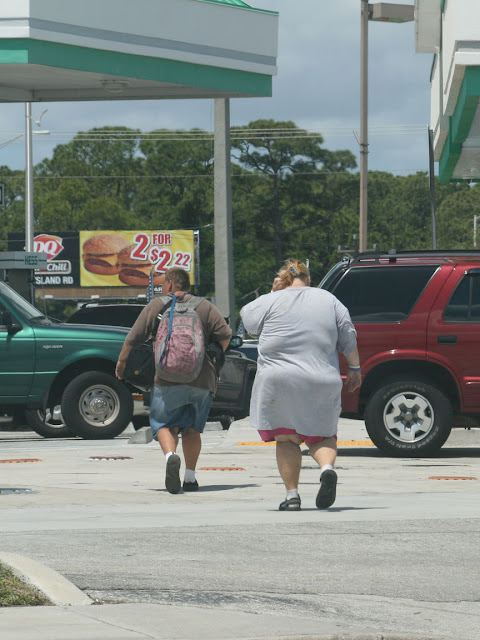
Fat City: Questioning the Relationship Between Urban Sprawl and Obesity

by Jean Eid, Henry G. Overman, Diego Puga, and Matthew A. Turner

The prevalence of obesity in the United States has increased dramatically over the last two decades. In the late 1970’s, 12.7% of men and 17% of women were medically obese. By 2000 these proportions had risen to 27.7% and 34% respectively (Flegal, Carroll, Ogden, and Johnson, 2002). Such a rise poses “a major risk for chronic diseases, including type 2 diabetes, cardiovascular disease, hypertension and stroke, and certain forms of cancer” (World Health Organization, 2003, p. 1), and has also been linked to birth defects, impaired immune response and respiratory function. Health spending on obesity related illness in the United States now exceeds that for smokingor problemdrinkingrelated illnesses (Sturm, 2002). In short, obesity is one of today’s top public health concerns.
Obesity rates have not increased at the same pace, nor reached the same levels, everywhere in the United States. For instance, between 1991 and 1998 the prevalence of obesity increased by 102% in Georgia but by only 11% in Delaware (Mokdad, Serdula, Dietz, Bowman, Marks, and Koplan, 1999). Similarly, while 30%of men and 37%of women in Mississippi were medically obese in 2000, the corresponding figures for Colorado were 18% and 24% respectively (Ezzati, Martin, Skjold, Hoorn, and Murray, 2006). Such large spatial differences in the incidence of obesity have led many to claim that variations in the built environment, by affecting exercise and diet, may have large impact on obesity. For instance, compact neighborhoods may induce people to use their cars less often than those where buildings are scattered. Similarly, neighborhoods where houses are mixed with a variety of local grocery stores and other shops may encourage people to walk more and eat healthier food than those where all land is devoted to housing. A growing and influential literature studies this connection between the built environment and obesity. Loosely, its main finding is that individuals living in sprawling neighborhoods are more likely to be obese than those who live in less sprawling neighborhoods.1 Evidence from some of these studies has prompted the World Health Organization, the us Centers for Disease Control and Prevention, the Sierra Club and Smart Growth America, among others, to advocate that city planning be used as a tool to combat the obesity epidemic.2 The vast sums that Americans spend on weight loss testify to the difficulty of changing the habits that affect weight gain. If changes to the built environment did indeed affect those habits, urban planning could be an important tool with which to curb the rise in obesity.
However, before we rush to redesign neighborhoods, it is important to note that a positive correlation between sprawl and obesity does not necessarily imply that sprawl causes obesity or that reducing sprawl will lead people to lose weight. For both genetic and behavioral reasons, individuals vary in their propensity to be obese. Many of the individual characteristics that affect obesity may also affect neighborhood choices. For instance, someone who does not like to walk is both more likely to be obese and to prefer living where one can easily get around by car. For such individuals obesity is correlated with, but not caused by, the choice to live in a sprawling neighborhood. That is, we may observe more obesity in sprawling neighborhoods because individuals who have a propensity to be obese choose to live in these neighborhoods. If such selfselection is important we can observe higher rates of obesity in sprawling neighborhoods even if there is no causal relationship between sprawl and obesity.


Fat people in the fat city, photo by Willie Lunchmeat 
more about urban sprawl: 

Suburban Immigrants Feel Arizona Heat

Land development, land use, and urban sprawl in Puerto Rico integrating remote sensing and population census data

Urban sprawl in Europe; The ignored challenge

Development at the Urban Fringe and Beyond: Impacts on Agriculture and Rural Land

By Ralph E. Heimlich and William D. Anderson

Land development in the United States is following two routes: expansion of urban areas and large-lot development (greater than 1 acre per house) in rural areas. Urban expansion claimed more than 1 million acres per year between 1960 and 1990, yet is not seen as a threat to most farming, although it may reduce production of some high-value or specialty crops. The consequences of continued large–lot development may be less sanguine, since it consumes much more land per unit of housing than the typical suburb. Controlling growth and planning for it are the domains of State and local governments. The Federal Government may be able to help them in such areas as building capacity to plan and control growth, providing financial incentives for channeling growth in desirable directions, or coordinating local, regional, and State efforts.


previous posts about urban sprawl:

Urban Sprawl Could Make Cities Hotter

Iraq's urban sprawl, not looting, threatens Ninevah antiquities

Is `new urbanism' truly a step in right direction?

A Libertarian View of Urban Sprawl


On Thursday, March 18, John Stossel‘s show on the Fox Business News network will feature a discussion of how taxes and regulation have prevented urban areas like Cleveland from recovering from the decline of the industries that once supported those regions.
While the “stars” of the show were Drew Carey and Reason Magazine’s Nick Gillespie, Stossel spent a few minutes on zoning and land-use regulation. When searching for someone to advocate such land-use regulation, they happened to ask James Kunstler, author of The Geography of Nowhere, a critique of suburbia.
Kunstler’s response was emphatic. First, he called one of Stossel’s other guests (okay, it was me) “a shill for the sprawl-builders.” Then he added, “Please tell Stoessel [sic] he can kiss my ass.” He was so proud of this response that he posted it on his blog (look for it in the archive if it has disappeared from his home page).
Kunstler is biased against mobility and low-density housing, but he must be a good writer because he has lots of fans. As soon as he posted his rude reply, the blogosphere lit up with arguments from progressive, conservative, and even libertarian writers claiming that sprawl is the result of central planning and zoning and therefore libertarians such as Stossel and Cato should support smart-growth policies aimed at containing sprawl.
Sprawl is “mandated by a vast and seemingly intractable network of government regulations, from zoning laws and building codes to street design regulations,” claims conservative Austin Bramwell. As a result, “government planning makes sprawl ubiquitous.”
Anarcho-libertarian Kevin Carson quotes The Geography of Nowhere as the authority for how planners like Robert Moses forced people to live in sprawl. “Local governments have been almost universally dominated by an unholy alliance of real estate developers and other commercial interests” that insisted on urban sprawl, says Carson.


Sprawl, by Billy V
more posts about urban sprawl:

URBAN SPRAWL AND CLIMATIC CHANGES IN TEHRAN

Suburban Immigrants Feel Arizona Heat

Brasilia, Brazil: economic and social costs of dispersion

Urban Sprawl Could Make Cities Hotter

by Alan Mozes

If global warming does drive temperatures upward, cities with urban sprawl may be more prone to extreme heat than less spread-out centers, new research suggests.
That means that sprawling metro-regions such as Tampa, Grand Rapids and Atlanta may be experiencing very hot days at more than double the rate of more dense cityscapes such as Chicago, Boston and Baltimore, said study lead author and urban planner Brian Stone of the Georgia Institute of Technology.
The difference may be caused in large part by deforestation, according to Stone. Between 1992 and 2001, such clearing of the "green" cover of trees and other vegetation -- previously shown to contribute to rising temperatures in cities -- was underway at more than twice the rate in sprawling regions than in dense urban centers.

read more

Chicago, by jonmartin ()


more about urban sprawl:

A comparison of urban shrinkage in Baltimore (Maryland, USA) and Osaka (Japan) : reversed patterns of urban decline ?

Urban Sprawl beyond Growth: from a Growth to a Decline Perspective on the Cost of Sprawl

Real Estate Brokerage to Unfettered Development: A History of Sprawl

Iraq's urban sprawl, not looting, threatens Ninevah antiquities


Nine-year-old Younis struggles to open the large iron padlock to the gates of Ninevah.
Younis, letting in visitors late one afternoon to the ancient site, is named after the prophet Jonah, who is said to be buried within the city walls of the Assyrian capital. It's a popular name here in the modern city that has sprung up within the ancient walls, threatening the undiscovered layers of civilizations underneath.
"There is very little left of Ninevah now because of the encroachment," says Muzahim Hussein, director of antiquities in Ninevah Province. Mr. Hussein says renovation in the 1990s of the Nebi Younis mosque – dedicated to the prophet Jonah and built on the site of an older church – destroyed part of the ancient city, across the river from modern Mosul.
"There are many treasures under there, but archaeologists could not stop the renovation," says Hussein, who believes there is an Assyrian palace buried underneath the site. "The department of antiquities could not stop the renovations because it was done by President Saddam Hussein himself, and because religiously, it's a holy place and you can't excavate near it or under it."
The Iraqi archaeologist's excavation at Nebi Younis in 1990 revealed neo-Assyrian sculptures that appeared to be the entrance to a palace. Hussein says he wrapped them in plastic and buried them again to hide and protect them.


A sample of the Assyrian artwork, by Kurt Thomas Hunt


more about urban sprawl:

Compact Sprawl Experiments Four Strategic Densification Scenarios for Two Modernist Suburbs in Stockholm

URBAN SPRAWL AND CLIMATIC CHANGES IN TEHRAN

E-book: Urban and Regional Planning

Friday, April 29, 2011

Social exclusion and transportation in Peachtree City Georgia

by Ruth Conroy Dalton

This paper will discuss how, in a small American city, Peachtree City (43km south of Atlanta), the flexibility and relative affordability of electric golf carts, as a viable alternative to the automobile, means that the level at which families and individuals are disadvantaged through their lack of access to public/private transport is effectively lowered. Economic access to golf carts, in of itself, would not be sufficient if it were not for the extensive, highly penetrative and ‘ringy’ spatial structure of the cart path system, a mostly-segregated, 150 kilometre network. A spatial analysis of this dual transportation system is presented and its implications discussed. The conclusion of this paper is that the duality of the effective spatial structure of the cart path network and the relative low cost and inherent flexibility of the golf carts combine to reduce transportation-linked social exclusion in Peachtree City. This argument is substantiated, in the final section of the paper, through the evidence of a questionnaire distributed to a random sampling of 1,038 property owners and renters in the city.


more Space Syntax papers:

Evaluated Model of Pedestrian Movement Based on Space Syntax, Performance Measures and Artificial Neural Nets

Compact Sprawl Experiments Four Strategic Densification Scenarios for Two Modernist Suburbs in Stockholm

THE STREETS OF INNOVATION: an exploratory analysis of knowledge transfer in the public realm

MEASURING WALKING. TOWARDS INTERNATIONALLY STANDARDISED MONITORING METHODS OF WALKING AND PUBLIC SPACE

by Daniel Sauter and Martin Wedderburn,

For many years walking had not been seriously considered as means of transport and, consequently, not been measured. In recent years we have seen, however, a slow change towards the better. New methods and tools to assess walking have been developed all over the world. Data is gathered, surveys, counts and audits are performed. In parallel, new technologies and equipment is being placed on the market. This is a big step forward. However, many exchanges and debates show one common problem: the incompatibility of data and methods. The European COST project 358 “Pedestrian Quality Needs PQN” (www.walkeurope.org) aims to publish (among other things) a consistent qualitative and quantitative methodology for recording pedestrian activity; easy to use auditing tools and guidance on national and local procedures for monitoring walking. Currently 20 European countries are participating in this project. In a first step we’re creating an overview of existing methods used to assess walking in the different European countries (a questionnaire has been circulated among participants). On this basis we started to discuss content and procedures to establish some common ground for the type of data to be collected and the adequate methods and tools to be used in order to make them internationally (more) comparable.
At the 7th WALK21 conference 2006 in Melbourne the International Charter for Walking has been adopted (for the conference series and the Charter please see www.walk21.com). It outlines what should be measured but it doesn’t say how this should be done. It is, therefore, logical and timely to make the next step and develop a set of “international guidelines for the collection, analysis and dissemination of qualitative and quantitative techniques for measuring walking”, as stated in the Melbourne conference conclusion. At the 2007 WALK21 conference in Toronto a day-long pre-conference workshop has been held to start the discussion and exchange of know-how globally. More than 30 experts attended the whole day session which resulted in a fruitful brainstorming on the many aspects of measuring walking. The debate will be continued at the 2008 WALK21 conference in Barcelona in October with a special focus on counting pedestrians. To this, city officials, experts and equipment providers will be invited.


more Space Syntax papers:

Flat City; a space syntax derived urban movement network model

Making an Urban Oasis The Use of Space Syntax in Assessing Dhanmondi Lake Revitalization Project in Dhaka, Bangladesh

Modeling street connectivity, pedestrian movement and land-use according to standard GIS street network representations: A Comparative Study

OPTIMAL LOCATION OF ROUTE AND STOPS OF PUBLIC TRANSPORTATION

by Tatsuya Kishimoto, Shutaro Kawasaki, Nobuhiko Nagata, and Ryosuke Tanaka

This study is concerned with the optimal location of route and stops of LRT and the effects of LRT in central urban areas. In order to implement LRT, it is important to locate LRT lines and stations in appropriate places and to estimate the effects of LRT. In this study we accordingly address the optimal layout of LRT route network and estimation of the effects. First, for the estimation of the effects of introducing LRT, a new evaluation model based on space syntax theory is proposed. Two indexes which explain traffic flows and the character of location are introduced. One is the average travel cost from nodes to nodes, which corresponds to the depth index of space syntax. The other is the amount of through traffic on each link, which is the frequency that a certain link (a road, train or LRT link) is chosen as a part of route for traveling from nodes to nodes in the city. The former is named C_depth value, and the latter is named Flow value.
Second, the optimal location of LRT route and stops, which minimizes the mean cost in whole area, is considered. The case of the new LRT system in Maebashi city in Japan is examined. Optimal location and its effects are investigated by case study in Maebashi City. Two types of optimal location are studied and compared. In both cases, Flows on LRT and trains are still lower than the Flow by cars on main streets. Thus, one conclusion may be that in order to promote LRT and train usages, policies, such as road-pricing and discount of LRT fare, are needed.


more Space Syntax papers:

A STUDY ON THE CORRELATION BETWEEN PEDESTRIAN NETWORK AND PEDESTRIAN VOLUME ACCORDING TO LAND USE PATTERN

MEASURING THE CONFIGURATION OF STREET NETWORKS: the Spatial profiles of 118 urban areas in the 12 most populated metropolitan regions in the US

Evaluated Model of Pedestrian Movement Based on Space Syntax, Performance Measures and Artificial Neural Nets

Wednesday, April 27, 2011

A STUDY ON THE CORRELATION BETWEEN PEDESTRIAN NETWORK AND PEDESTRIAN VOLUME ACCORDING TO LAND USE PATTERN

by Haeng Woo Shin, Young Ook Kim, and Ah Hyun Kim

This study aims to clarify the characteristics of pedestrian space use patterns according to land use by analyzing the correlation between pedestrian network and pedestrian volume in downtown Seoul. The study method is as follows: first, the present condition of the land was investigated; second, a pedestrian network was created using space syntax and pedestrian volume examined; and third, the correlation between pedestrian volume and pedestrian network according to land use was analyzed.
The results indicated that the correlation between pedestrian volume and spatial network in residential areas was very low (R^2=0.07), while there was a close relationship between pedestrian volume and spatial network in business areas (R^2=0.872). With respect to the commercial areas, the pedestrian volume characteristic of the entire commercial area surrounding Namdaemun Market and that of Namdaemun Market itself were different: where the correlation between pedestrian volume and spatial network was high (R^2=0.694) in the commercial area excluding Namdaemun Market, but became low when the market was included.
As the results show, there was a very close correlation when it was broken down and analyzed according to the type of land use, which signifies that correlation between pedestrian network and pedestrian volume differ according to land use. The study results also suggest that when planning for pedestrian space, business and commerce areas need a plan that puts more emphasis on spatial network over comfort of pedestrian environment, and in case of residential areas, comfort of pedestrian walkways are more important than spatial network.


more about urban Korea:

New City Landscape - Seoul

The Colourful Buses of Seoul

seoul: buses that tell you where they go?

Is `new urbanism' truly a step in right direction?

By Arrol Gellner

In recent years, a whole passel of architecture has marched under the banner of "new urbanism," a movement that seeks to counter the alienation of suburban sprawl and to rekindle human interaction in our communities.
Inspired by the smaller-scale and pedestrian focus of turn-of-the-century towns, a lot of new urban design has had heartening success.
In big cities such as Chattanooga, Tenn., and tiny ones such as Suisun City, Calif., revamped neighborhoods that combine human scale, mixed-use planning, carefully varied architecture and a focus on foot-traffic have yielded vibrant places in which humans, and not just cars, can interact.
In residential design, new urbanism has its own set of hallmarks. Prominent front porches, for example, are meant to encourage neighborly interaction, while garages are banished to the rear of building lots to help break the automobile's stranglehold on the street.

read more


previous articles about New Urbanism:

From Suburb to City: An Opportunity Born of Necessity

New globalism, new urbanism: gentrification as global urban strategy

New Urbanist Silverback Andres Duany and the Young Locusts

The New Urbanism: Kichijoji Style

New Urbanism's latest recruit is the military

By William L. Hamilton

One of the newer suburban developments in Fairfax County, Va., is the Villages at Belvoir.
Belvoir is Ft. Belvoir, a military post. And the "villages," 15 New Urbanist towns, are on-post housing for soldiers and their families.
The first, Herryford Village, was occupied last year: 171 townhouses and single-family homes designed in a local Georgian Colonial style. It has a Main Street with shops and a clock tower, playgrounds and village greens with open-air pavilions and centralized mailboxes where residents can socialize informally. There is not a tin hut or cinderblock house in sight.
Since the Department of Defense began privatizing its housing in 1996 (more than 128,000 units to date), replacing and upgrading an antiquated stock through partnerships with the private sector, the armed services have started running in some surprising architectural circles.


read more articles about New Urbanism:

How do we create places where people want to work, live and play?

Three Urbanisms: New, Everyday and Post

How Urban Design Affect Personal Activity and Travel Choice - An Analysis of Travel Data from Sample Communities in Adelaide

New Urbanism and the rebuilding of Mississippi

via The Oil Drum

The article touches on a number of issues demonstrating why the ideal (at least, the New Urbanists' ideal) is hard to achieve. As many of you know, the idea behind New Urbanism is that many amenities, such as the post office, shops, food, and the town center, should all be within walking distance of people's residences. So the first issue this raises, of course, has to do with poverty. Part of the plan involves building new houses, and in fact, the issue of affordability was addressed, but the question of "affordable to whom" still remained. Andres Duany, one of the main architects of New Urbanism and the man contacted for the Mississippi job, projected that "affordable" houses could be built for $145,000. The problem was that the lower working class is only able to afford houses between $65,000-$95,000. Said one person from the poor, black community—which was not consulted about the plans— 

read more

more about New Urbanism:

One problem with New Urbanism is its lack of flexibility

New Urbanism in Memphis and Atlanta

Designing Community: The Utopia of New Urbanism

New Urbanists Who Admire Singapore’s Urban Planning

neo-traditional development: a post modern way in urban design

Tuesday, April 26, 2011

MEASURING THE CONFIGURATION OF STREET NETWORKS: the Spatial profiles of 118 urban areas in the 12 most populated metropolitan regions in the US

by John Peponis, Douglas Allen, Dawn Haynie, Martin Scoppa, and Zongyu Zhang

In this paper we report an analysis of 118 urban areas sampled from the 12 largest metropolitan regions in the US. We deal with familiar measures of block size, street density, intersection density and distance between intersections. We also introduce two new variables, Reach and Directional Distance. Reach is the aggregate street length that can be accessed from the midpoint of each road segment subject to a limitation of distance. Directional distance is the average number of direction changes needed in order to access all the spaces within reach. We provide parametric definitions of these variables and implement their computation using new software which runs on standard GIS representations of street center lines.


more about Space Syntax:

Evaluated Model of Pedestrian Movement Based on Space Syntax, Performance Measures and Artificial Neural Nets

Compact Sprawl Experiments Four Strategic Densification Scenarios for Two Modernist Suburbs in Stockholm

THE STREETS OF INNOVATION: an exploratory analysis of knowledge transfer in the public realm

Evaluated Model of Pedestrian Movement Based on Space Syntax, Performance Measures and Artificial Neural Nets

by F L Zampieri, D Rigatti, and C Ugalde
To understand the generating causes of pedestrian movement is very important for urban planning tasks, because it is possible to infer if attitudes taken in the conception and maintenance of the spaces are in fact contributing to the social dynamics. However, to determine pedestrian flows is a difficult task due to the complexity of people movement. A way to outline this problem is through the creation of models which associate the attributes and their relationships directly to the studied phenomena. The model used here uses two kinds of variables: the configurational ones obtained through the axial map of the city where the study area is located, and the performance measures obtained through the physical evaluation of the attributes of the sidewalks of the studied area. The output of the model is the mean pedestrian rate of the area. The Syntax Space theory is useful for understanding the phenomenon because of the way it deals with space interaction. However, though it is able in predicting part of the movement, we do not find significant correlations when the measure of intelligibility is low. Pedestrian flows are a complex phenomenon and, per se, cannot be understood through linear relationships among any couple of variables, being them spatial or not. In this paper it is argued that the space syntax theory and measures explain the pedestrian movement as a phenomenon emerged from society, but the linear approach is not capable of explaining their relationships. The presented model uses Artificial Neural Nets (ANN), a parallel processing tool with the capacity of working through examples, learning, generalizing and abstracting the variables information and their connections. The implementation of these kinds of models evolves from 'black boxes' to models that can be 'disassembled' and evaluated inside of its logical structure. The ANN uses two groups of data: one for training nets and the other one for validating the network. Thus, the performance of the ANN can be tested with unknown data. The results produced so far have shown that ANN can learn the main features of the data sets with an accuracy of more than 90% of correlation coefficient and with an average error smaller than 0.02. It must be said that the research work targets to spread the samples from different configurational realities and expand the data bank on measured movement in order to improve the accuracy of the model, such as being done lately.


more papers about Space Syntax:

Flat City; a space syntax derived urban movement network model

Making an Urban Oasis The Use of Space Syntax in Assessing Dhanmondi Lake Revitalization Project in Dhaka, Bangladesh

Modeling street connectivity, pedestrian movement and land-use according to standard GIS street network representations: A Comparative Study

Compact Sprawl Experiments Four Strategic Densification Scenarios for Two Modernist Suburbs in Stockholm

by Alexander Ståhle and Lars Marcus

One of the biggest challenges for future urban design is to cope with suburbia and sprawl. This paper investigates how sprawl can be compacted in terms of spatial morphology. New 'user-related' location density measures, like spaciousness and compactness, are introduced that integrate floor area, axiality of pedestrian network, and public open space. These and 'administrative' area density measures are applied to two modernist suburbs in Stockholm, Björkhagen and Rågsved (1946-1957), and four strategic densification scenarios: 'New urbanism', 'New regularism', 'New conservatism', and 'New modernism'. The results show that the suburbs can increase by 100% in Floor Area Ratio in the first two and but only 20-40% in the other two. Floor area accessibility, however, is influenced by network accessibility more than plot density. Public open space is needed to uphold spaciousness and compactness. To conclude, tree-like morphologies seem rational in peripheral low density suburbs with a lot of public open space, but when densified the grid becomes more necesary to uphold compactness. Even though densification by 'New urbanism' or 'New regularism' in modernist suburbia is improbable due to political reality, they point out possible ways to compact more efficiently modernist sprawl as well as the need for further research.


more posts about Space Syntax:

SPATIAL GROWTH AND FUNCTION IN A JAVANESE COASTAL CITY

Agent-based Simulation of Human Movement Shaped by the Underlying Street Structure

Space Syntax and Transit Networks

THE STREETS OF INNOVATION: an exploratory analysis of knowledge transfer in the public realm

by Pete Ferguson

This paper investigates the possible mechanisms by which spatial structure can affect patterns of networking and knowledge transfer in the public realm. Drawing on the work of ‘The space of innovation’ (Penn, Desyllas, Vaughan 1999) into the distribution of interaction inside individual office buildings, the research translates a selection of their methodologies to the public realm of central Birmingham and the City of London. Gate counts and extended observations are undertaken to identify the spatial distribution of gross pedestrian flow, interaction whilst walking and encounter. These results are then related to various spatial measures for analysis.
The research reveals that the level of gross pedestrian flow or static activity in space is not always an indicator of the vibrancy of interaction in the public realm. Analysis reveals that interaction while moving appears to relate strongly with spatial measures even when gross pedestrian flow does not and that levels of encounter in space increase as a proportion of pedestrian flow as spatial accessibility increases. As a result, small stretches of pavement aside busy road environments are often shown to be the most conducive to networking activities and that high levels of activity in less accessible public spaces are not accompanied by an increased level of encounter.
The paper concludes that the level and consistency of interface between different scales of movement affects the efficiency of networking and knowledge transfer both externally and internally to organisations. The concept of radial constancy is used as a means of describing the equality and consistency of access to space for different journey distances and consequently, a spaces ability to create opportunities for encounter and interface between scales of movement.
Considerable further research is required to validate research findings in alternate locations and to directly test radial constancy values against the spatial distribution of recorded observations.


other posts about Space Syntax:

An integration of space syntax into GIS for modelling urban spaces

SPATIAL GROWTH AND FUNCTION IN A JAVANESE COASTAL CITY

Agent-based Simulation of Human Movement Shaped by the Underlying Street Structure

Space Syntax and Transit Networks

Sunday, April 24, 2011

One problem with New Urbanism is its lack of flexibility

by Randy Bright

I have just read a most insightful paper regarding New Urbanism entitled, “Village Vices: The Contradiction of New Urbanism and Sustainability.”
It was written by Ruth Durack, who is now the director for the Urban Design Centre in Western Australia. At the time she wrote the paper in 1998, she lived in the United States and it won second place in the 1998 Chicago Institute for Architecture and Urbanism Award. It was later published in Places Journal, which is produced by the UC Berkeley College of Environmental Design.
The driving force behind New Urbanism is to achieve sustainability by returning people to cities designed to a standard that essentially exemplifies a traditional English village. The classic definition of sustainability assumes that the resources of the earth are finite, and that the present generation must conserve resources for future generations.
But Durack successfully challenged the notion that we must all fit into a New Urbanistic mold to accomplish what needs to be accomplished in order to achieve sustainability.
There may be as many definitions of sustainability as there are people. I would not presume to know what Durack’s political beliefs are, but she gives a definition of sustainability that varies only slightly from the classic definition, but with a key distinction: “sustainability refers to development that satisfies the choices of the present without compromising the ability of future generations to make choices of their own.”


The back of the houses in Vickery - Forsyth County, GA , photo by joeventures

more about New Urbanism:

New Urbanism Now: Catching up with Andrés Duany

Designing Community: The Utopia of New Urbanism

Sustainable Development Ends Suburban Sprawl

New Urbanism in Memphis and Atlanta


Twice I read Derek Merrill & Beau B. Beza's essay in Refractory: a Journal of Entertainment Media. The writers utilize the concept of the "screen" to explore Atlantic Station development in Atlanta, Georgia. Atlantic Station is a environmental urban brownfield redevelopment and reclamation of the 100-year-old Atlantic Steel Mill requiring the removal of 9,000 dump truck loads of contaminated soil. The 138-acres are divided into three zone: mixed use outdoor shopping mall with 6 million SF of office highrise space, mid-rise apartments surrounding a wetland and the IKEA store. Due to the terrain and earth removal, all the public parking is below ground providing much more flexibility in pedestrian space design.  
I wrote Merrill and Beza that the screen was a poor choice of words to assist with the analysis. It was a forced metaphor regarding the spatial conception. I visit as many new urbanist places as possible to understand them. The designers conceive these developments as a series of territorial types, which are set next to each other. Each territory has an aesthetic heart (round, linear or grid) that is defined with building facades. 


Harbor Town, Mud Island, Memphis, Tenn.,photo by ilovememphis

more articles about New Urbanism:

New Urbanism and Planning History: Back to the Future

New Urbanism Now: Catching up with Andrés Duany

In Markham, the dream of an urban village that never was

New Urbanism: A Salve or Bane to Urban Wounds?

Skyline photos of Hamburg, Germany 1

Skyline photo of Hamburg, by frankartculinary

Hamburg skyline, photo by frankartculinary

Hamburg skyline, by HH-Michael

Hamburg skyline, by frankartculinary

Hamburg skyline, by Edgar Zuniga Jr.

Hamburg skyline, by Mark Max Henckel
more skyline photos:

Skyline photos of Manila, Philippines 1

Skyline photos of Portland, Oregon 1

Skyline photos of Berlin 1

Skyline photos of Copenhagen, Denmark 1

Friday, April 22, 2011

An integration of space syntax into GIS for modelling urban spaces

by Bin Jiang, Christophe Claramunt and Björn Klarqvist

In the past, many methods of spatial analysis have been developed for a better understanding and modelling of real-world phenomena. However there is still a need for exploration of new analytical techniques for modelling urban spaces. Space syntax models the spatial configurations of urban spaces by using a connectivity graph representation. Such a configuration of space identifies patterns that can be used to study urban structures and human behaviours. This paper proposes methodological and practical evaluations of the potential of the space syntax approach within GIS. We present the main principles that are the basis of space syntax, in addition to methodological perspectives for a closer integration with GIS, which should be of use for many GIS applications, such as urban planning and design.


more Space Syntax papers:

SPATIAL GROWTH AND FUNCTION IN A JAVANESE COASTAL CITY

Agent-based Simulation of Human Movement Shaped by the Underlying Street Structure

Space Syntax and Transit Networks

SPATIAL GROWTH AND FUNCTION IN A JAVANESE COASTAL CITY

by Endang Titi Sunarti DARJOSANJOTO

This study addresses the question “What is the appropriate design solution for the developed streets of a Javanese coastal city” The presentation focuses on three major streets in the northern part of the city of Surabaya, which have spread outwards from the historic core. GIS-GRASS, a Geographical Information System, can be used to map areal objects such as land-use, the role and function of streets in the city, traffic, movement and static activities, and linear objects such as rivers and the boundaries of areal planning units. The spatial database recorded here includes the configurational mapping of space syntax. For the local government, whose concern is to prepare design solutions which take account, inter alia, of the role of the street within the configuration of the city as a whole, this is a valuable tool.


other Space Syntax papers:

Planning a Deep Island: introducing Space Syntax to an urban planning process for Phuket, Thailand

New Developments in Space Syntax Software

Modeling street connectivity, pedestrian movement and land-use according to standard GIS street network representations: A Comparative Study

Agent-based Simulation of Human Movement Shaped by the Underlying Street Structure

by Bin Jiang and Tao Jia

Relying on random and purposive moving agents, we simulated human movement in large street networks. We found that aggregate flow, assigned to individual streets, is mainly shaped by the underlying street structure, and that human moving behavior (either random or purposive) has little effect on the aggregate flow. This finding implies that given a street network, the movement patterns generated by purposive walkers (mostly human beings) and by random walkers are the same. Based on the simulation and correlation analysis, we further found that the closeness centrality is not a good indicator for human movement, in contrast to a long standing view held by space syntax researchers. Instead we suggest that Google’s PageRank, and its modified version - weighted PageRank, betweenness and degree centralities are all better indicators for predicting aggregate flow.


previous papers:

Space Syntax and Transit Networks

Exploring Multi-layered Hyper Dense Urban Environments through Spatial Analysis

The spatial congruence effect: exploring the relationship between spatial variables and functional vitality on Lisbon's prime office location.

Space Syntax and Transit Networks

by Joshua Weiland

This paper looks at nineteen subway systems from around the world, and the relationship between two sets of spatial properties and system ridership. The first hypothesis is subway systems’ intelligibility (Hillier, 1996, p. 129) is correlated to boardings. Second, a proof-of-concept will be attempted, hypothesizing that in the Washington Metro, stations’ integration, connectivity and total depth (Hillier, 1996) are correlated to boardings. The method of analysis was successful, but only one set of hypotheses was supported: intelligibility is not shown to be correlated to ridership, but all three syntactic attributes were shown to be correlated to the Washington Metro’ station boardings.


other Space Syntax papers:

THE EFFECTS OF PROPOSED BRIDGES ON URBAN MACROFORM OF ISTANBUL: a syntactic evaluation

Planning a Deep Island: introducing Space Syntax to an urban planning process for Phuket, Thailand

Analysis of urban complex networks

Exploring Multi-layered Hyper Dense Urban Environments through Spatial Analysis

by Stephen Law and Yunfei Zhao

With ever increasing pressure on space and natural resources, the planning and design of hyper dense urban environments may become a reality for many city authorities. As a result, studies in hyper dense environments proves valuable for practitioner and academics a like. Space syntax is a spatial analysis that studies the relationship between spatial configuration and pedestrian behaviour in urban environment. The analysis has been described to only partially capture the distribution of movement in areas with heterogenous distribution of population density. Henceforth, the study of hyper dense urban environments raises a number of challenges for existing space syntax methodologies. This paper tests the degree to which public realm simulations are able to decode the distribution of pedestrian movements in hyper dense environments, namely in a district of central Hong Kong. Beyond this the paper explores additional urban design parameters for assessing multi layers environments towards more accurate representations. The paper finds that while two dimensional spatial modelling techniques provide an intuitive description of spatial structure in such environments, certain techniques accounting for other urban design parameters are needed to aid existing methodologies in deconstructing formal structure at a higher resolution and provide solid correlations with indicators such as pedestrian movement distributions. The results of the study was positive with the space syntax measures achieving a positive correlation (r-square=0.48). In the end, the factor of proximity to number of plots(morphological differences) and influences on elevation(elevation differences) were concluded to have strong combinatorial influences on pedestrian movement distribution in this area of the city. These additional parameters were tested as binary factors (0 and 1) in a multiple variate correlation that gave a strong correlation. (r-square =0.80) The evidence suggests further research is needed to address the degree to which these additional factors can have on the patterns of pedestrian movement distribution as well as testing the methodology in other parts of the city.


more Space Syntax papers:

Planning a Deep Island: introducing Space Syntax to an urban planning process for Phuket, Thailand

New Developments in Space Syntax Software

Modeling street connectivity, pedestrian movement and land-use according to standard GIS street network representations: A Comparative Study

The spatial congruence effect: exploring the relationship between spatial variables and functional vitality on Lisbon's prime office location.

by Pinelo,J. and Heitor, T.

This paper presents an exploratory study on spatial determinants of urban land uses patterns aimed at exploring the relationship between spatial variables and functional vitality in the urban environment. It investigates the importance of the spatial congruence effect on office location patterns i.e., the adequacy between extrinsic and intrinsic spatial variables. Extrinsic properties refer to topological variables while intrinsic properties consider physical variables, both influencing space use (Hillier, 1999). The research question is focused on the main physical characteristics, which influence use location in the case of prime offices.
Spatial congruence concept emerges from the evidence of two urban phenomena: the existence of hierarchies at both functional and spatial level, and the assumption that they are very directly related. Both phenomena are well documented facts (Hillier, 1976; Tannenbaum, 1995; Hillier, 1991; Alexander, 1965).
Previous space syntax research has shown very consistent correlations between spatial and functional hierarchies (Desyllas, 1999; Hillier, 1999; Kim, 2002). Based on the results of an empirical study of Lisbon’s Prime Zone (FA, 2000), this paper argues that healthy urban environments lay on the congruence of global and local spatial properties i.e., on the adequacy between extrinsic and intrinsic properties. Referred study has showed a very consistent coincidence between highest integration values and highest office rents, i.e., a strong relationship between spatial and functional hierarchies. However, within the spaces with highest integration values, one showed a different functional performance when compared to the others. Besides having a different functioning, it also accommodates some activities associated to urban decay.


more papers about Space Syntax applications:

Flat City; a space syntax derived urban movement network model

Making an Urban Oasis The Use of Space Syntax in Assessing Dhanmondi Lake Revitalization Project in Dhaka, Bangladesh

Modeling street connectivity, pedestrian movement and land-use according to standard GIS street network representations: A Comparative Study

WHAT INTEGRATION ADDS TO QUALITY OF LIFE

by Rômulo José da Costa Ribeiro and Frederico Rosa Borges de Holanda

There are various indicators of quality of life, among them the well known Human Development Index (UN). The paper explores ways of including configurational dimensions in the definition of such indexes. It superimposes the integration measure of Space Syntax Theory and socioeconomic indicators mainly based in education, health and income levels, as well as the localization of jobs and the distribution of the varied residential densities in the city. It is argued that the procedure is telling as far as the relationships between the various social classes and the city are concerned. The Federal District in Brazil, i.e. the national capital Brasilia, is the case-study. The city presents many peculiarities that are further illuminated by the findings of the paper. Brasilia presents the lowest average density among Brazilian State Capitals. Furthermore, a study carried out among 58 cities of all continents, indicates Brasilia as the second most dispersed city in the world (an attribute that is independent of average density). Brasilia also concentrates immediately around its CBD more than 80% of all formal jobs in the metropolis. Finally, the rich live near the centre and the poor in the peripheral satellite nuclei, as in other cities in Brazil. Such peculiarities imply that relative localization of homes, jobs and services are more important than elsewhere in contributing to the standards of living. Here, to be (syntactically) integrated and rich, and (syntactically) segregated and poor, means a high bonus to the former and a heavy burden to the latter. Traditional socioeconomic indicators such as the Human Development Index miss important attributes that characterize the standard of living in Brasilia. Analysis will be carried out in minute detail, using the census sectors as the basic spatial unit. Census sectors are geo-referenced and include the basic socioeconomic indicators that are needed. GIS tools will be used in order to correlate syntactic integration with the variables of the census sectors. We will end by "weighting" the quality of life indexes by means of configurational measures at a global level of the city, and arrive at a sociospatial quality of life indicator, that includes dimensions which are absent in current indexes of standards of living.


previous papers about the applications of the Space Syntax theory:

Poverty and Connectivity: Crossing the Tracks

QUANTIFYING THE QUALITATIVE: an evaluation of urban ambience

Evaluating urban ambience – an investigation into quantifying the qualities of the walkable city

Thursday, April 21, 2011

Poverty and Connectivity: Crossing the Tracks

by Ann Carpenter and John Peponis

The spatial structure of cities influences the patterns of development and the spatial distribution of income groups. Past studies have shown that historically the integration of streets is a strong predictor of wealth and poverty in London. Although the current societal and regulatory characteristics of Atlanta, Georgia, U.S.A. differ considerably from those that have historically prevailed in London, recent research has shown that street network integration and connectedness correlate significantly with measures of wealth and poverty in different manners at different scales. The spatial concentration of poverty and the segregation of income classes are associated with specific problems in the U.S. as elsewhere: negative externalities include poor access to employment, lack of social networking opportunities, vulnerability, psychosocial effects, political disenfranchisement, and the inadequate provision of services, shops, and amenities. The poor tend to be less mobile, making the spatial mismatch between jobs and low-income housing a significant concern for planners and policy makers. Vulnerability to crime and lack of resistance to disasters are also serious problems. As witnessed in New Orleans after Hurricane Katrina, poor neighborhoods have fewer resources and insufficient social and physical infrastructure for rebuilding or transforming unfavorable urban conditions. Finally, the funding of public schools and patronage at inner-city hospitals is tied to the income of surrounding neighborhoods in the U.S., thus making the equitable provision of services harder.
This paper seeks to understand how urban form, specifically measures of street connectivity, relate to poverty in Atlanta. Initial results indicate that at the scale of larger spatial units, or U.S. Census block groups, connectivity increases as the number of households living in poverty increases. This trend expresses the tendency whereby middle and upper income groups have fled to the suburbs and peripheral urban centers since the 1960s. However, using household-level and other finer-scale data, the results invert. Within a local area, connectivity is associated with an increase in household income. The segregation of income groups by neighborhood is responsible for the larger-scale trend, while the recent popularity of neo-traditional and mixed-income housing as part of a return to a more urban life style for the middle classes may contribute to the smaller-scale trend.


more papers about Space Syntax indicators:

THE EFFECTS OF PROPOSED BRIDGES ON URBAN MACROFORM OF ISTANBUL: a syntactic evaluation

Planning a Deep Island: introducing Space Syntax to an urban planning process for Phuket, Thailand

WALKABILITY, MOVEMENT AND SAFETY FOR THE CITY OF BERKELEY