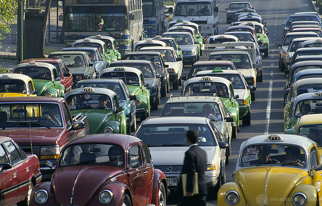
Latin American cities have experienced significant urban sprawl over the past century, characterized by the uncontrolled expansion of urban areas into peripheral zones. This phenomenon has been closely linked to socio-economic factors, car ownership, and the availability of public transportation. To understand the current landscape, it's essential to delve into the historical trajectory of urbanization in the region. In this video, I try to historically explain the relationship between urban sprawl in Latin American cities and socioeconomics as well as car use in 20th and 21st centuries. I will also provide some short inputs about five metropolises in Lartin America: Mexico City, Sao Paolo, Bogota, Buenos Aires, and Lima.
Current Status of Urban Sprawl
Today, Latin American cities are among the most urbanized globally. As of 2013, approximately 80% of the region's population resided in urban areas, a significant increase from 50% in 1970. This rapid urbanization has often led to sprawling metropolitan areas with inadequate infrastructure and services.
Historical Urbanization Trends in the 20th Century
Early 20th Century
In the early 1900s, Latin America was predominantly rural, with a majority engaged in agriculture. Cities like Buenos Aires, Mexico City, and São Paulo were emerging as economic centers, attracting rural migrants seeking better opportunities. However, urban growth was relatively modest during this period.
Post-World War II Boom
The aftermath of World War II marked a turning point. Industrialization accelerated, leading to a surge in urban migration. Between 1950 and 1980, the urban population in Latin America grew from 50 million to over 200 million. Cities expanded rapidly, often without proper planning, resulting in informal settlements and inadequate infrastructure.
Socio-Economic Factors and Urban Sprawl
Economic growth in the mid-20th century led to the expansion of the middle class, increasing demand for housing. However, limited affordable housing in central areas pushed populations toward the peripheries, contributing to sprawl. Additionally, socio-economic disparities meant that while wealthier individuals could afford centralized housing, lower-income groups settled in less accessible outskirts.
Car Ownership and Its Impact
Rising incomes in the post-1950s made car ownership more attainable. For instance, between 1990 and 2010, per capita car ownership in Mexico more than doubled from about 75 to 175 cars per 1,000 people, and nearly tripled in Brazil from 45 to 125 cars per 1,000 people. This surge facilitated suburban living but also led to increased traffic congestion and pollution.
Public Transportation Challenges
Despite urban expansion, investments in public transportation lagged. Many cities relied on informal transport systems, leading to inefficiencies. For example, in Mexico City, the metro system, inaugurated in 1969, couldn't keep pace with the city's growth, resulting in overcrowded trains and buses. By 2017, longer trips were more likely to be made by private car rather than public transit, exacerbating congestion.
Case Studies
Mexico City, Mexico
As one of the world's largest metropolises, Mexico City exemplifies urban sprawl. The city's area expanded from 1,500 km² in 1950 to over 7,800 km² by 2000. Car ownership surged, with the vehicle fleet growing by 30% between 2010 and 2018. Despite an extensive metro system, the city's public transportation has struggled to keep up with demand, leading to increased reliance on private vehicles.
São Paulo, Brazil
São Paulo experienced rapid urbanization post-World War II, with its population swelling from 2.2 million in 1950 to over 12 million today. The city's car fleet grew by 22% between 2010 and 2018. Efforts to implement bus rapid transit (BRT) systems have been made, but challenges remain in reducing traffic congestion and promoting public transit use.
Bogotá, Colombia
Bogotá has faced significant urban sprawl, with its population increasing from 700,000 in 1951 to over 7 million by the early 21st century. The city introduced the TransMilenio BRT system in 2000, aiming to improve public transportation. While initially successful, the system has faced challenges due to increased demand and insufficient capacity.
Buenos Aires, Argentina
Buenos Aires saw its car fleet grow from 2.4 million in 2010 to 4.2 million in 2018, a 75% increase. The city's public transportation includes buses, trains, and the Subte (subway), but the rise in car ownership has led to increased congestion and longer commute times.
Lima, Peru
Lima's car fleet doubled from 0.9 million in 2010 to 1.8 million in 2018. The city has implemented the Metropolitano BRT system to address transportation needs, but urban sprawl continues to pose challenges for infrastructure development.
Conclusion
The historical trajectory of urban sprawl in Latin American cities is deeply intertwined with socio-economic factors, car ownership, and public transportation development. Addressing the challenges of sprawl requires integrated urban planning, investment in efficient public transit, and policies that promote sustainable urban growth.
More about Latin America: