Like Urban Research on Facebook

Showing posts with label The Netherlands. Show all posts

Wednesday, January 8, 2025

How Shipping Containers Revolutionized Urban Life

 Shipping containers: simple metal boxes, yet they’ve reshaped cities and economies in profound ways. From revolutionizing global trade to creating modern architectural marvels, let’s dive into how these steel giants have transformed our urban landscapes.


Port of Rotterdam: The Birthplace of Containerization

The Port of Rotterdam in the Netherlands became a global pioneer in container shipping during the 1960s. This port, now the largest in Europe, played a crucial role in adopting containerization—a method of transporting goods in st
andardized containers. This innovation revolutionized global trade by drastically reducing shipping times and costs. For example, before containerization, unloading a ship could take up to 10 days, but with containers, the same process now takes mere hours.

The economic ripple effect was massive. By the 1970s, Rotterdam was handling millions of TEUs (twenty-foot equivalent units) annually, becoming a hub of global commerce. The efficiency of containers also reshaped port cities. While cities like Rotterdam boomed, others struggled; smaller ports couldn’t keep up with the infrastructure demands of containerization, leading to economic shifts across regions.

Container Architecture: From Cargo to Creativity

Beyond ports, shipping containers have been repurposed into innovative urban structures. Their affordability, durability, and modular design have made them ideal for architectural experiments.

In London, the Boxpark Shoreditch turned shipping containers into a vibrant shopping and dining complex. Opened in 2011, this “pop-up mall” offers an affordable space for small businesses, making it a model for urban revitalization.

In Johannesburg, the Drivelines Studios repurposed 140 containers into a chic residential complex. These apartments are eco-friendly, cost-effective, and perfect for addressing urban housing challenges in growing cities.

Even beyond these examples, containers are used for schools, offices, and emergency shelters worldwide. Their versatility showcases how urban planners can repurpose industrial tools to meet modern needs.

The Downsides of Containerization

However, the rise of containerization hasn’t been without drawbacks. Container ports require vast amounts of space and heavy machinery, often displacing communities and altering cityscapes. For instance, the expansion of the Port of Los Angeles led to increased air pollution and the displacement of nearby neighborhoods. The benefits of containers often come at an environmental and social cost, reminding us that urban innovations must balance efficiency with equity.

Conclusion: Metal Boxes, Infinite Potential

From the bustling Port of Rotterdam to container homes in Johannesburg, shipping containers exemplify how innovation can reshape cities. These unassuming steel boxes have connected the world, transformed architecture, and driven urban economies. As we rethink urban spaces, the journey of the humble shipping container reminds us of the endless potential hidden in everyday objects.

 More about architecture: 

SPACE EFFICIENCY IN HIGH-RISE OFFICE BUILDINGS

Saturday, August 31, 2019

Revisiting Urban Planning in Developed Countries

By Pietro Garau

The purpose of this paper is to describe urban planning trends in the so-called “developed countries”. And indeed, the countries under examination will be precisely those still falling under this category. Throughout this paper, however, the vast region to which they belong will be referred to as “The North”. One reason for this is that, to this author as well as to many others, it is increasingly difficult to define to what kind of end state the terms “developed” and its complementary one, “Developing”, should represent, or aspire to. When the term was coined, it was universally believed that development referred largely to the improvement of economic performance. Then, in 1989, came UNDP’s historic definition of “human development”, which expanded the concept of development to include such factors as educational attainment, health, and gender parity. After that, we began to see that “development” was a moveable object whose contours depended on the bundle of indicators chosen to define and measure it. 


France, Strasbourg

More about urban planning and policy making:

Tuesday, February 13, 2018

Promoting Schoolchildren's Physical Activity by Change in Transport to School Behavior: Statistical Analysis

By Houshmand E. Masoumi

During the past decade, a number or researchers have focused on the interdisciplinary topic of active transport to school (ATS) and children’s health and wellbeing including their body weight and Body Mass Index (BMI). Most of the recent studies are focused on a handful of high-income societies, leaving other countries less researched. Thus, this study targeted both high-income and less-studied contexts within the European context. The aim was to provide reliable inter-contextual data for facilitating comparative studies as well as undertaking preliminary analyses on the contextual differences in children’s walking to school, relationships between parent’s commuting mode choice and that of their children, the associations of built environment with ATS and BMI, and finally noteworthy points for interventions for promoting children’s school-based physical activity. Using the results of surveys undertaken in nine European cities in 2016, statistical analyses were conducted, which led to preliminary results confirming strong significant associations of the built environment with children’s ATS as well as strong and significant associations of parents’ commute mode choice with that of their children. These preliminary results do not confirm significant differences between walking to school in different European contexts. It is probable that these differences exist regarding biking to school, but this may be tested in future research. This study underlines the circumstances of planning a more active school commuting behavior in the future of European societies: activation of 9-12-year-old European children’s school commuting is recommended to be done by changing the parent’s commute mode choices as well as integrating urban planning, transportation planning, and school site selection in future urban plans. Awareness of policy makers, families, and also children may be essential in planning more active school commuting. Applying the results of the surveys done during this project, future research will target inter-contextual differences between factors such as physical activity, ATS, and BMI, correlations between the perceptions of children and parents regarding school commuting and neighborhood and the associations with physical activity and BMI, the possible importance of city size in determining all the above factors regardless of the national context, and the differences between the tendencies and phenomena influencing school commuting-related physical activity and BMI in emerging European countries compared to high-income countries.

Read more  

 
Schools Out Girls

More about children's active commuting to school:

Tuesday, August 8, 2017

Urban Design and the Changing Context of Urban Regeneration in the Netherlands

By Paul STOUTEN,

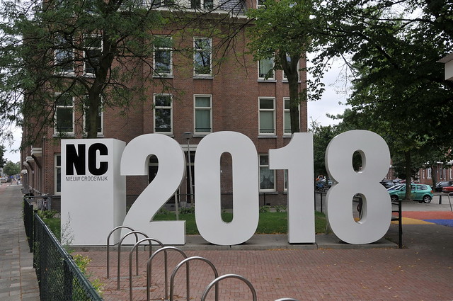
Urban design schemes accompanied by avant-garde design of space have been an outcome of economic growth of cities and countries in many periods of time. At the beginning of the 21st century, Nieuw Crooswijk in Rotterdam was the largest area involved in nationally launched policies. Many times the conflicts surrounding the plan were in the news, particularly concerning the aim to attract higher incomes. Gentrification, with displacement of present and original residents forms a central issue and the discussions in Nieuw Crooswijk fit within the more general urban landscape and language of urban regeneration in Europe.


'Nieuw Crooswijk 2018' Rotterdam

More about the Netherlands:

Photos of bike lanes in Amsterdam, Netherlands (1)

Residential self-selection and travel: The relationship between travel-related attitudes, built environment characteristics and travel behaviour

The World's 7 Most Bike-friendly Cities

Graffiti photos of Rotterdam, Netherlands

BEST PRACTICE IN FACILITATING AND PROMOTING ACTIVE TRAVEL

Thursday, August 3, 2017

Children’s Travel to School and their Body Weight; Results of a Survey in Seven European Countries: Technical Report

By Masoumi, Houshmand, E.; Zanoli, Gabriele; Papageorgiou, Athanasios; Smaga, Soultana; Miloš, Ana; Van Rooijen, Martin; Łuczak, Monika; Komorek, Joanna; Çağan, Birol; Calabrese, Carla; E. Jamerson, Gordon; Patsakas, Georgios; Parisopoulos, Georgios; Meimaridis, Ioannis; Anagnostaras, Konstantinos; Perrostis, Andreas; Dessi, Eleni; Družeta, Toni; Udović, Tatjana; Daams, Ingmar; Drużek, Paweł, and Dalcı, Ahmet 


Problem: A number or researchers have recently focused on the interdisciplinary topic of active transportation of children and adolescents, their physical activity, and their body weight as an important aspect of their health. Such studies have been dominantly undertaken in a specific geographical context. Lack of contextual studies necessitates data collection with samples covering different countries and/or regions applying a uniform methodology. Such a lack of data is observed in both Europe and overseas.
Objective: This survey attempts to collect dissaggregate data about the travel behaveior of children of 9-12 years of age and their parents, children’s body specifications, and their households characteristics as well as aggregate data about the built environment of their school.
Method: direct questioning based on a standard questionnaire consisted of 26 questions was conducted in spring and summer of 2016 in nine cities in seven European countries (Foggia, Italy; Berlin, Germany; Thessaloniki, Greece; Rijeka, Croatia; Utrecht, The Netherlands; Łódź, Poland, Konstantynow, Poland; Malatya, Turkey, and Doğanşehir, Turkey).
Results: Out of 2735 children handed out the questionnaires, the parents of 1424 schoolchildren filled out the questionnaires, 1304 of which were validated and kept for analysis. This makes an overall response rate of 52.07 percent. In this report, the researchers of M.A.P.S. project have provided detailed descriptive findings separately for each case-study citiy as well as for the whole cities together as one sample.

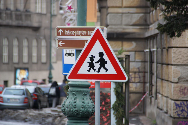
Warning Sign "Children" in Prague, Czech Republic

More about urban planning and children's health:

Active Transport to School and Children's Body Weight: A Systematic Reivew

Active transport to school and the risk of obesity


Systematic Review of Active Commuting to School and Children’s Physical Activity and Weight

Walking, Cycling, and Obesity Rates in Europe, North America, and Australia

Societal trends, mobility behaviour and sustainable transport in Europe and North America

Thursday, May 2, 2013

Residential self-selection and travel: The relationship between travel-related attitudes, built environment characteristics and travel behaviour

by Wendy Bohte

Most national governments of Western countries aim to influence the travel patterns of households – at least to some degree – through the spatial planning of residential areas. Over time and between countries, the main aims of spatial policies have varied, from reducing congestion, reducing travel times, reducing environmental pollution, increasing liveability to preserving rural landscapes. Today, maintaining and improving accessibility for economic reasons, the depletion of fossil fuels and the reduction of carbon dioxide emissions to limit climate change are the major reasons for influencing travel behaviour (e.g. Hilbers et al., 2006; OECD, 2007; TRB, 2003; Van den Brink and Van Wee, 2001). In addition, health professionals have recently called on spatial planners to develop residential areas that promote walking and cycling (e.g. Frumkin et al., 2004; NICE, 2008).
Nonetheless, in most countries the extent to which policies are put into practice is limited. Over the last few decades, the Netherlands has probably had the most far-reaching mobility aims in its spatial planning policies. In the 1970s the Third National Policy Document on Spatial Planning aimed at reducing car mobility. Policies aimed to increase the use of slow modes and public transport through undertaking new developments in existing urban areas, providing high-quality public transport in the newly developed areas andmixed land use (housing, work and recreation) at the urban regional level. New employment locations were to be situated near railway stations. In 1973 the national government prohibited large-scale out-of-town retail developments to protect city centres and prevent an increase in car use (Evers, 2002).
Spatial policy aiming at urban concentration was intensified in the following two decades, with the introduction of the compact city policy. The Fourth Report on Spatial Planning Extra (Ministerie van Volkshuisvesting, Ruimtelijke Ordening en Milieubeheer, 1991) resulted in the development of so-called VINEX locations. These are large new residential areas situated within or adjacent to medium to large-sized cities, aiming to provide good accessibility by public transport and bicycle. Living, working and personal care was to take place at the level of the urban region to reduce mobility and protect rural areas (Snellen and Hilbers, 2007).


kortegracht-amersfoort-dec2011b
Amersfoort, Netherlands
Langegracht, Amersfoort
Amersfoort, Netherlands

more about travel behavior:

Integrating Transport, Land-Use Planning and Environment Policy in European Countries

MODELLING AND PROSPECTS OF THE AUDIENCE MEASUREMENT FOR OUTDOOR ADVERTISING BASED ON DATA COLLECTION USING GPS DEVICES (ELECTRONIC PASSIVE MEASUREMENT SYSTEM)

QUALITATIVE METHODS IN TRAVEL BEHAVIOUR RESEARCH

Dynamic GPS-position correction for mobile pedestrian navigation and orientation

Documentary film: Sprawling from Grace: The Consequences of Suburbanization

The Effects of Teleshopping on Travel Behavior and Urban Form

Modelling Perceived Accessibility to Urban Amenities Using Fuzzy Logic, Transportation GIS and Origin-Destination Surveys

Thursday, November 29, 2012

Opportunities for transport mode change: an exploration of a disaggregated approach

by Martin Dijst, Tom de Jong, and Jan Ritsema van Eck

Research into the effects of spatial configuration on the use of transport modes has to date dominantly been based on analyses of actual travel behaviour or prediction of future transport mode choices. However, in this research it is not made clear what choice opportunities were available for travel behaviour of the various population categories, given their desired activities and time-space opportunities. The authors describe a time-space theoretical and methodological framework based on the concept of action spaces, within which the choice opportunities of different types of house- holds of various areas can be analysed. On the basis of a pilot study among the residents of a suburban neighbourhood in a Netherlands new town, the time space opportunities they have to use alternative transport modes other than the car are brought into the frame. It is shown that residents have more time-space opportunities to make use of existing environmentally friendly, transport modes than had been expected. The possibilities differ between types of action spaces and types of households. Some implications for policymaking are discussed. The authors state that policymakers should be more sensitive to interpersonal differences in accessibility.


Similar posts:

Correlating Densities of Centrality and Activities in Cities: the Cases of Bologna (IT) and Barcelona (ES)

Geographically Weighted Regression: A Method for Exploring Spatial Nonstationarity

Correlating street centrality with commerce and service location in cities

Street Centrality and Densities of Retails and Services in Bologna, Italy

Monday, June 18, 2012

Urban Environmental Management in (M.Sc.) Wageningen University, The Netherlands

The world we live in is an increasingly urban one as cities currently account for half the world’s population. By 2030, it’s expected that three out of every five people will live in an urban environment. Sustainable management of the urban environment has become one of the major challenges of the 21st century as you will learn during the two-year Master Urban Environmental Management programme at Wageningen University. This development calls for control of the environmental impacts of urbanisation like growing traffic, increasing waste emissions, deteriorating air and water quality, and growth in energy and resource consumption. Inadequate water supply, sanitation, waste collection and waste management systems are the cause of serious urban pollution and health hazards in many Asian, African and Latin American cities. Student like you are needed to guide the future along the path of sustainable urbanisation.
The Urban Environmental Management programme consists of courses, an internship and a research thesis. The thesis programme is the individual research project that forms the core component of this Master programme. Students can major in one of seven Urban Environmental Management disciplines thereby further tailoring their study to their personal interests. These are Environmental Policy, Environmental Economics, Environmental Systems Analysis, Urban Environmental Technology and Management, Geo-Information Science and Remote Sensing, Land Use Planning, Management Studies. 
Graduates with a Master of Science in Urban Environmental Management are well-equipped with the skills and knowledge to continue academic training (PhD) or to enter or continue careers in city management, environmental research, urban planning and environmental consulting, water, waste management and transport, construction and building stock management.


DSC_0653Wageningen campus at night more master's programmes in urban planning:

Research M.Sc. in Urban Studies, University of Amsterdam, The Netherlands

Master's programme in Sustainable Urban Planning and Design in KTH Royal Institute of Technology, Sweden

The Master’s Degree Programme in Multidisciplinary Studies on Urban Environmental Issues (MURE), University of Helsinki, Finland

Master of Landscape Architecture, University of Texas, Arlington

Master of architecture, University of Sydney, Australia

Master of Urban Design Studies- University of Toronto

Research M.Sc. in Urban Studies, University of Amsterdam, The Netherlands

Urban Studies

The 21st century will be an urban century. It is expected that the largest cities and metropolitan regions of Europe, North America and Japan will keep growing, even though the population of especially Europe and Japan as a whole will decline. Contrary to the earlier ideas about the global economy becoming increasingly ‘footloose’, large cities and metropolitan areas will remain the most important economic hubs of this part of the world. In other parts of the world like China, Latin America, the Middle East and Africa, cities are still growing very fast because of migration from the rural areas to the cities. Some of the largest cities of ‘the global South’ are becoming serious competitors in the global economy too. Both in the North and South, cities are more and more international and interconnected.
  • What are the consequences of this urban growth and change for urban societies?
  • Are integration, segregation and polarisation increasingly problematic?
  • How can we plan and manage this urban growth and change locally and regionally?
  • What does the shift from ‘government’ to ‘governance’ mean for the urban and regional planning process?
  • Which cities are competitive, which are not, and why?
These are some of the many questions and challenges we discuss in our Research Master Urban Studies.
Our programme combines the disciplines of urban geography, economic geography, urban and regional planning, and urban sociology, providing a multidisciplinary and comprehensive approach to urban change. An important theme throughout the programme is the international comparison of urban phenomena. Thematic courses are combined with advanced research methodology courses, a stay abroad and research projects under supervision of leading experts in urban studies. Students will acquire sound theoretical and methodological knowledge and the research skills to start a career in the social sciences, or to work in relevant policy fields like housing, planning or social policy, or in related commercial sectors like real estate or property development.

Studying Urban Studies at the University of Amsterdam

The programme makes full use of its location in the thriving metropolis of Amsterdam through organising excursions to projects and neighbourhoods in the city and other Dutch urban centres, which are intended to acquaint students with urban praxis in the Netherlands. Student exchange agreements with foreign universities offer students the opportunity to study in cities such as New York, London and Berlin and to become familiar with other university cultures and city life in other countries. The programme has strong ties with the Amsterdam Institute for Social Science Research: the leading professors of four of AISSR's research groups are responsible for the core courses of the MSc; students will work together with these professors in a research apprenticeship and a research article; and students are invited to attend academic activities at AISSR.
read more 

University of Amsterdam University of Amsterdam  

more master's peogrammes in urban planning:

Master of Urban and Regional Planning (MURP)-Portland State University

MSc in Spatial Planning- University of Dundee

Master of City Planning in Boston University

Master's programme in Sustainable Urban Planning and Design in KTH Royal Institute of Technology, Sweden

Wednesday, May 30, 2012

Local level application of the dynamic land use model METRONAMICA: Assessment and modelling – a case study on the Dutch municipality Weert

by Sophia Christine Linke

Policy makers, who are faced with decision making about spatial activities in urban areas, can be guided by means of computer based decision support systems. An example of such support systems are land use models, offering important benefits and assistance. The land use model METRONAMICA is such a decision support system. Its allocation methodology is based on a cellular automaton. The model is interactive and user-friendly, facilitates learning and employs complex and weakly-structured decision contexts.
For the thesis at hand a study area in the Netherlands, the municipality Weert, was chosen. Here, several major changes and redevelopments are planned but different opinions considering future growth perspectives exist. METRONAMICA could be used for developing them. The question is, if the model provides accurate results and usable support when being applied at a high resolution and local level.
In the course of the study METRONAMICA’s possible application is tested and evaluated. First METRONAMICA is compared to a selection of other spatial models (CLUE, LandUseScanner, UrbanSim and SLEUTH). Keeping in mind the local scale of application, the availability of suitable data then is assessed, input datasets are created and suitable variables are chosen while carrying out the model calibration. For assessing the quality of calibration, two measurements are applied: Kappa statistics and Zipf’s law. Special attention is paid to the applied cell size (25 x 25 m) and the size of the neighbourhood the cellular automaton takes into consideration (8 cell and 16 cell radius neighbourhood). In order to evaluate METRONAMICA’s possibilities for local planning support, several development scenarios are created and simulated until the year 2040.
The results show, that a local application seems to be possible, but more detailed data should be inserted into the modelling environment to be able to model more detailed land use functions (e.g. splitting up the urban land uses). Then, also much more detailed transition rules could be implemented, accounting for dynamics within the urban environment. The simulation results obtained show a remarkable difference between the 8- and 16-cell neighbourhoods. The model was calibrated with an 8-cell neighbourhood, and then the neighbourhood extended to 16 cells, resulting in very blobby simulation result. The model should hence fully be calibrated again. Changing the neighbourhood while expecting to achieve better simulation results, seems only possible when adapting also the transition rules.


more about land use models:

SIMULATING URBAN AND REGIONAL EVOLUTIONS: SCENARIOS OF DEVELOPMENT IN THREE STUDY CASES: ALGARVE PROVINCE (PORTUGAL), DRESDEN-PRAGUE TRANSPORT CORRIDOR (GERMANY-CZECH REPUBLIC) AND FRIULI-VENEZIA GIULIA REGION (ITALY)

Land use change modelling in an urban region with simultaneous population growth and shrinkage including planning and governance feedbacks

Incremental Integration of Land Use and Activity-Based Travel Modeling: Workplace Choices and Travel Demand

Review of existing land/use transport models

A model of residential location choice with endogenous housing prices and traffic for the Paris region

A STRUCTURAL EQUATIONS MODEL OF LAND USE PATTERNS, LOCATION CHOICE, AND TRAVEL BEHAVIOR IN SEATTLE AND COMPARISON WITH LISBON

Friday, February 10, 2012

The World's 7 Most Bike-friendly Cities

via momondo

Bike capital of the world; 40% of Amsterdam’s traffic is by bicycle and the 750.000 residents own an estimated 600.000 bicycles. Bikes are by far the most popular means of transport, partly due to that fact that it’s almost impossible to drive a car around the narrow streets with canals, and due to the high price of parking – if you are lucky enough to find a spot to park.
Just about everybody cycles in Amsterdam – and it’s not unusual to see mothers, 2 kids and shopping all on the same bike. With its extensive network of routes dedicated to cyclists, plenty of places to park (Amsterdam is building a 10.000-bike parking garage at the main train station) and its bike culture, Amsterdam is a great place to cycle.
...
photo by korafotomorgana

With a vibrant bike culture, I'm not sure that many Copenhagerners agree that Amsterdam is the world's bike capital. Approximately a third of Copenhagen’s resident’s cycle to work daily – including myself. With an extensive network of dedicated paths, separated from the main road – including traffic lights specifically for cyclists – cycling is a quick and practical way to get around.
The local council is planning to on doubling its spending on cycling infrastructure during the next couple of years, and already parts of town are car-free and taking a bike for free on the subway system enables you to cycle further afield.
To encourage tourists to enjoy Copenhagen by bike, the city provides more than 2000 public bicycles, which can be found throughout the downtown area. Simply deposit 20 dkr to unlock your bike from one of the 100 cycle racks and enjoy your trip. Your money is refunded, when you return the bike to one of the racks.


more about bicycle planning:

Paris to Allow Cyclists to Run Red Lights

BEST PRACTICE IN FACILITATING AND PROMOTING ACTIVE TRAVEL

Bicycle Use and Safety In Paris, Boston, and Amsterdam

Bicycle policies of the European principals: continuous and integral

Innovative Urban Transport Concepts Moving from Theory to Practice

Metroradruhr: Germany's Ruhr Valley Inter-City Bike Sharing

Bike Share: A slice of Paris in Chicago


Tuesday, January 31, 2012

Graffiti photos of Rotterdam, Netherlands

Graffiti in Rotterdam, Netherlands, photo by mediadeo

Graffiti in Rotterdam, Netherlands, photo by stevent

Graffiti in Rotterdam, Netherlands, photo by tdietmut

Graffiti in Rotterdam, Netherlands, photo by tdietmut

Graffiti in Rotterdam, Netherlands, photo by tdietmut

Graffiti in Rotterdam, Netherlands, photo by FaceMePLS

Graffiti in Rotterdam, Netherlands, photo by Akbar Sim (busy)

Graffiti in Rotterdam, Netherlands, photo by tdietmut

Graffiti in Rotterdam, Netherlands, photo by Ozute
more graffiti photos:

Revolutionary graffitis in the streets of Cairo, Egypt

Artbase Grabowsee – Urban Art Festival

Graffiti photos of Boston

Grafitti photos, Los Angeles 1

Grafitti photos, Atlanta 1

Graffiti photos, Amsterdam 1

Graffiti photos, London 1

Monday, January 23, 2012

BEST PRACTICE IN FACILITATING AND PROMOTING ACTIVE TRAVEL

via Department for Regional Development

“Policies and strategies at all levels advocate walking and cycling but motor transport still takes priority in the big decisions and in the allocation of investment. As a consequence the UK lags badly behind many European countries in levels of active travel. To return walking and cycling to levels that can contribute to a healthy society, changes are needed in policy and practice.”1
A number of papers exist summarising the success of The Netherlands, Denmark and Germany in promoting active travel, especially cycling. Pucher et al Making Cycling Irresistible: Lessons from The Netherlands, Denmark and Germany, 2008;2 Buehler et al Sustainable Transport that Works: Lessons from Germany, 2009;3 Atkins, European Best Practice Report, 2006;4 Jacobs Consultancy, European Best Practice Report, Final Report December 2006.5 Some of these successes are discussed in more detail in the next section.

German bikers, by Qlis

more about travel behavior in urban areas:

OVERVIEW OF LAND-USE TRANSPORT MODELS

Building More Roads Does Not Ease Congestion

How Urban Design Affect Personal Activity and Travel Choice - An Analysis of Travel Data from Sample Communities in Adelaide

Effects of Site Design on Pedestrian Travel in Mixed-Use, Medium-Density Environments

Comparative Study of Pedestrian Travel Culture in Different Cities in Japan